Srisailam Tourism | Tourism Places near Srisailam | AP TOURISM
Srisailam is a census town in Kurnool district of the Indian state of Andhra Pradesh. It is the mandal headquarters of Srisailam mandal in Kurnool revenue division. The town is famous for Mallikarjuna Jyotirlinga Temple and is one of the holy pilgrimage site for Saivism and Shaktism sects of Hinduism. The town is classified as both Jyotirlinga and Shakti Peetha.
Srisailam Tourism: The Tourism of Srisailam Destination & Travel Guide | AP Tourism
Srisailam is one of the popular tourist destinations in Andhra Pradesh and considered as one of the most important pilgrimage centres of Lord Shiva.
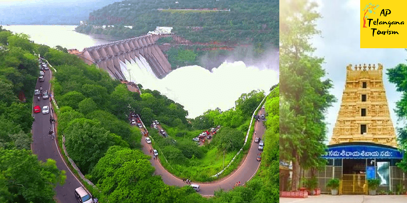
1.Srisailam Dam which was built over Krishna river is one of the largest dams in South India.
2.Nagarjunsagar-Srisailam Tiger Reserve, India’s largest tiger reserve is spread over 3500 km2. This Sanctuary is a natural habitat of diverse species of flora and fauna. The lush and dense Nallamala Forest range is a popular destination for trekking, hill climbing, forest exploration and research, to which Srisailam town acts as a base camp.
3.Mallikarjuna Jyotirlinga enshrines Lord Mallikarjuna and is an ancient temple built in a Dravidian style with specimens showcasing the Vijayanagara architecture.
4.Akka Mahadevi Caves, Pathalaganga, Shikareshwara Temple are few other attractions in this place.
Mallikarjuna Jyotirlinga:
Sri Bhramaramba Mallikarjuna Temple or Srisailam Temple is a Hindu temple dedicated to the deities Shiva and Parvati, located at Srisailam in Indian state of Andhra Pradesh. It is significant to the Hindu sects of both Shaivam and Shaktam as this temple is referred to as one of the twelve Jyothirlingas of Lord Shiva and as one of the eighteen Shakti Peethas of goddess Parvati. Shiva is worshiped as Mallikarjuna, and is represented by the lingam. His consort Parvati is depicted as Bhramaramba. It is the one of the only three temples in India in which both Jyotirlinga and Shaktipeeth is revered.
Legend:
The legend is that Kumar Kartikeya, the younger son of Lord Shiva once got angry and came to the Kronch Hills from Kailash. Lord Shiva and Maa Parvati came here and stayed on with the name Arjun and Mallika. Thus the place and the temple were called Mallikarjun.
When Shiva and Parvati decided to find suitable brides for their sons, Ganesha and Kartikeya argued as to who is to get married first. Shiva bade that the one who goes around the world in Pradakshinam could get married first. By the time Kartikeya could go round the world on his vahana, Ganesha went round his parents 7 times (for according to Shastras, going in pradakshinam round one’s parents is equivalent to going once around the world (Bhupradakshinam)). Siva got Buddhi (intellect), Siddhi (spiritual power), and Riddhi (prosperity) married to Ganesha. Kartikeya on his return was enraged and went away to stay alone on Mount Kraunja in the name of Kumarabrahmachari. On seeing his father coming over to pacify him, he tried to move to another place, but on the request of the Devas, stayed close by. The place where Shiva and Parvati stayed came to be known as Shrishailam.
As per Hindu legend, the presiding deity in the form of Linga (an iconic form of Shiva) was worshipped with jasmine (locally called Mallika), leading to the name of presiding deity as Mallikarjuna. Mahashivratri is the main festival celebrated at Srisailam Mallikarjuna Swamy temple.
Transport:
The nearest railway station are Markapur is 85 km, Nandyal and Kurnool are the places the distance is 180 km. The most convenient way is to take a bus or taxi from Hyderabad. Temple committee cottages and dharamshalas are available here.
Lord Shiva in this temple is referred to as one of the twelve Jyotirlingas. Goddess Bramarambha’s shrine is referred to as one of the fifty two Shakti peethas. This temple is classified as one of the Paadal Petra Sthalam. On the way to the main temple is located Shikreshwar temple.It is said that by having darshan in the temple one does not get rebirth. Krishna River here is called Patal Ganga. One has to go down 852 stairs to reach the river. The Shiva Linga is bathed with the water of this river.
12 Jyotirlingas:
Originally there were believed to be 64 jyotirlingas while 12 of them are considered to be very auspicious and holy. Each of the twelve jyotirlinga sites take the name of the presiding deity – each considered different manifestation of Shiva. At all these sites, the primary image is lingam representing the beginningless and endless Stambha pillar, symbolizing the infinite nature of Shiva. The twelve jyotirlinga are Somnath in Gujarat, Mallikarjuna at Srisailam in Andhra Pradesh, Mahakaleswar at Ujjain in Madhya Pradesh, Omkareshwar in Madhya Pradesh, Kedarnath in Himalayas, Bhimashankar in Maharashtra, Viswanath at Varanasi in Uttar Pradesh, Triambakeshwar in Maharashtra, Vaidyanath at Deoghar district in Jharkhand, Nageswar at Dwarka in Gujarat, Rameshwar at Rameswaram in Tamil Nadu and Grishneshwar at Aurangabad in Maharashtra.
Shakti Peethas:
Srisailam Sri Mallikarjuna Swamy Temple is one of the 18 Maha Shakti Peetha. The legend of Daksha Yaga and Sati’s self-immolation resulted in the emergence of Sri Parvati in the place of Sati Devi and making Shiva a householder. This mythology is the story behind the origin of Shakti Peethas. They are holy abodes of Adiparashakti formed due to the falling of Sati Devi’s corpse when Shiva carried it and wandered. It is believed that Sati Devi’s Upper lip has fallen here.
Maha Shiva Ratri is the most important festival here. Along with Dasara Sarannavartrulu.
Srisailam Dam:
The Srisailam Dam is constructed across the Krishna River in Kurnool district, Andhra Pradesh near Srisailam temple town and is the 2nd largest capacity working hydroelectric station in the country. The dam was constructed in a deep gorge in the Nallamala Hills in between Kurnool and Mahabubnagar districts, 300 m (980 ft) above sea level. It is 512 m (1,680 ft) long, 145 metres (476 ft) maximum height and has 12 radial crest gates. It has a reservoir of 616 square kilometres (238 sq mi). Project has an estimated live capacity to hold 178.74 Tmcft at its full reservoir level of 885 feet (270 m) MSL.
The Srisailam project began in 1960, initially as a power project. After several delays, the main dam was finally completed twenty years later in 1980 July 26. In the meantime the project was converted into a multipurpose facility with a generating capacity of 770 megawatts (1,030,000 hp) by its second stage which was completed in 1987.
At present the initial inflows into Srisailam reservoir are stored excessively without using for power generation. The flood water fills the remaining empty Srisailam reservoir quickly and most of the flood water overflows into downstream Nagarjunasagar reservoir without being used for power generation. The endeavor shall be to fill the Nagarjunasagar reservoir fully with the uniform water released through the power generating units.
Best Tourism Places near Srisailam: Awesome Tourist Places near Srisailam You must visit
Nagarjuna sagar-Srisailam Tiger Reserve:
Nagarjunsagar-Srisailam Tiger Reserve is the largest tiger reserve in India . The reserve spreads over five districts, Kurnool District, Prakasam District, Guntur District, Nalgonda District and Mahbubnagar district. The total area of the tiger reserve is 3,728 km2 (1,439 sq mi). The core area of this reserve is 1,200 km2 (460 sq mi). The reservoirs and temples of Srisailam are major attraction for many tourists and pilgrims. It is the largest tiger reserve forest in India.
This reserve is located between longitude: 78°30′ to 79°28′ east and latitude: 15°53′ to 16°43′ north. Elevation varies from 100 m (330 ft) to 917 m (3,009 ft) above mean sea level.
Average annual rainfall is 1,000 mm (39 in).The hill ranges contain a number of plateaus, of which, Amrabad, Srisailam, Peddacheruvu, Sivapuram, and Nekkanti are noteworthy. Nagarjunasagar receives rains from the southwest monsoon, which is active from the second half of June to the end of September. The Krishna river cuts its basin almost 200 m (660 ft) deep over a distance of 130 km (81 mi) through the reserve. There are several waterfalls in the reserve such as the Ethipothala Falls, Pedda Dukudu, Gundam and Chaleswaram.
The ancient temples at Srisailam of Lord Mallikarjuna and his consort goddess Bhramaramba, an incarnation of Parvathi as the fair-complexioned boon from Brahma, contain one of the twelve sacred Shaiva Jyotirlingas and one of the eighteen Maha Shakthi peethas in India.
This area contains ruins of Nagarjuna Viswa Vidyalayam. The site was once the location of many Buddhist universities and monasteries.
The ruins of a fort of the 3rd century BCE Indian ruler, Ikshwaku Chandragupta overlook the Nirjivapuram (Lifeless city) valley. The ancient fort of king Pratap Rudra of the Kakatiya dynasty and several other forts are visible on the banks of the Krishna River. An ancient 105 mi (169 km) wall constructed there by the Kakateeyas is an impressive historic feature.
This area contains several rock shelters and cave temples including: Akka Mahadevi Bhilam, Dattatreya Bhilam, Umaa Maheswaram, Kadalivanam, and Palankasari.
Flora:
The main types of forest biomes in the reserve are: southern tropical dry mixed deciduous forest, Hardwickia forest and Deccan thorn scrub forests with much Euphorbia scrub. Important plant species here are: Anogeissus latifolia (axlewood), Cleisthanthus collinus (odcha), Terminalia spp., Pterocarpus marsupium, Hardwickia binata (anjan tree), Boswellia serrata (Indian frankincense or salai), Tectona grandis (teak), Mundulea sericea and Albizia spp. (silkplants).
Fauna:
The main mammals in the reserve are: Bengal tiger, Indian leopard, sloth bear, Ussuri dhole, Indian pangolin, chital, sambar deer, chevrotain, blackbuck, chinkara and chowsingha. Lesser fauna include mugger crocodile, Indian python, Indian Cobra, Ptyas mucosa, Bengal monitor, Indian Star tortoise and Indian peafowl.[2] Endemic reptiles like the skinks Ashwamedh writhing skink, Sharma’s mabuya] lizards and the Nagarjun Sagar racer snake are particular highlights of this unique region.
Nallamala Forest:
Nallamala Forest is located in the Indian state of Andhra Pradesh and Telangana. It is part of the Eastern Ghats.
The Nallamalas (also called the Nallamalla Range) are a section of the Eastern Ghats which stretch primarily over Kurnool, Nellore, Guntur, Prakasam, Kadapa and Chittoor districts of the state of Andhra Pradesh and Mahabubnagar, Nalgonda districts of the state of Telangana, in India. They run in a nearly north-south alignment, parallel to the Coromandel Coast for close to 430 km between the rivers, Krishna and Pennar. Its northern boundaries are marked by the flat Palnadu basin while in the south it merges with the Tirupati hills. An extremely old system, the hills have extensively weathered and eroded over the years. The average elevation today is about 520 m which reaches 1100 m at Bhairani Konda and 1048 m at Gundla Brahmeswara.[1] Both of these peaks are in a north westerly direction from the town of Cumbum. There are also many other peaks above 800m.
The rocks of the Nallamala ranges belong to the Kadapa system which is a series some 20,000 ft. thick.[3] The primary rocks are Quartzite overlaid with an irregular slaty formation. Some sandstone is also to be found. The rocks here are very irregular and soft in texture thus rendering commercial exploitation impossible. These rocks are among the oldest in the world and have been formed as a result of large scale volcanic activity hundreds of millions of years ago. The evidence of the volcanic forces are evident in the foldings into which the rocks have been forced.
The Nallamalas have a rather warm to hot climate throughout the year. Rainfall averages about 90 cm and is concentrated in the months of the South West Monsoon (June–September). The fissured rocks prevent any water from percolating underground and hence most of the discharge runs off as mountain streams to join the Gundlakamma River, the largest river to arise in these hills. Winters are mostly cool and dry with the average temperature around 25 degrees Celsius.Summers are very hot,with temperatures as high as 45 degrees celcius.
These hills are almost completely covered with open jungle. Lack of water prevents the growth of large trees and the prevalent vegetation consists of Terminalia, Hardwickia and Pterocarpus. Agriculture is almost non existent apart from isolated patches near villages where subsistence farming is practiced. The Nallamala Forests are probably the largest stretch of undisturbed forest in South India apart from the Western Ghats and were particularly rich in game till the 1970s. A large part of the forest is a part of the Nagarjunsagar-Srisailam Tiger Reserve that has a viable tiger population. Leopard sightings too are not uncommon. Many of the adventures of the popular wildlife writer, Kenneth Anderson are set in these forests. The uneven terrain and the scarcity of water has prevented the growth of any large cities in this region. Kurnool is the largest city in this region with Nandyal being the second largest and little nearer than Kurnool to the forest. The indigenous population consists of the Chenchus, a forest dwelling tribe who have remained cut off from the modern world even today. Farming is the primary occupation of the people in the plateaus while the Chenchus are still hunter gatherers. The hills were a hotbed of Naxal activities until recently. Police action since 2005 has all but cleared the forest of them.
Transport:
A state highway and the Nallapadu-Nandyal line of the Guntur railway division pass through the hills. The railway was first built by the Madras and Southern Mahratta Railway and is a feat of engineering, having 2 tunnels at Bogada and Chelama and a few viaducts, the most famous being the now abandoned Dorabavi Viaduct. The railway enters the hills at the Nandikama Pass near Cumbum Lake. The highway follows a zig zag alignment and thus avoids any tunnels. The primary exports of this region are forest produce like timber waste, honey and molasses.
Srisailam on the River Krishna is the site of a large hydroelectric power project as also an ancient temple dedicated to Lord Shiva. Mahanandi temple and Ahobilam Nava Narsimha Temples are situated here. A stream descends down the Gundla Brahmeswara peak and ends in a waterfall and sacred pool called Nemaligundam (Peacock Pool). The Mallela Theertham waterfall on the river Krishna is also located in this forest.
The Cumbum Lake is one of Asia’s oldest man made lakes and dates back to the 15th century. It was built by the Gajapati kings of Orissa for irrigating about 420 km2 farmland by damming a narrow opening between two adjoining hills and later renovated by queen Vardarajamma of Vijayanagara kingdom in the 16th Century.
Ahobilam:
Ahobilam is a village and holy site in the Allagadda mandal of Kurnool district in the Indian state of Andhra Pradesh. It is surrounded by picturesque hills of the Eastern Ghats with several mountain hills and gorges. It is the centre of worship of Narasimha, the lion-headed avatar of Vishnu, to whom the nine Hindu temples and other shrines all dedicated. The main village and a temple complex are at Lower Ahobilam. Upper Ahobilam, about 8 kilometres to the east, has more temples in a steep gorge.
The temple consists of nine shrines to Narasimha, located around a 5 KM circle. In addition to the nine shrines, there is a temple for Prahaladavarada Varadhan in the foothills of the mountain. Due to security reasons and the difficulty in performing daily worship, many of the utsava vigrahas of the nine shrines are kept in this temple. To visit the entire group still involves some relatively arduous walking.
The main Narashima temples at each site were built or expanded by the kings of Vijayanagara in the 15th and 16th centuries, then sacked by the Mughals in 1578, then restored and expanded at various times, up to the present day. As they stand, they are a mixture of work from all these periods.
Ahobilam is traditionally regarded as the place where Vishnu in the form of Narasimha killed the rakshasa Hiranyakashipu in order to save his devotee Prahlada. The legend says that Narasimha emerged from a rock pillar to kill the rakshasha. The moment is represented in a number of murti in the various temples. Also, Garuda prayed for a vision of Narasimha in the form of Avathara, to fulfil his wish, and settled in nine forms across the hills in Ahobilam. Ahobilam is located at 15.1333°N 78.7167°E. It is located in Nallamala Forest, along the Eastern Ghats.
Mahanandi:
Mahanandi, is a village located east of the Nallamala Hills near Nandyal, Kurnool District, Andhra Pradesh, India. It is surrounded by forests. Within 15 km of Mahanandi, there are nine Nandi shrines known as Nava nandulu. Mahanandi is one of the Nava Nandis. The Mahanandiswara Swamy Temple, an important shrine, is located here. This ancient temple dates back over 1,500 years. The inscriptions of 10th century tablets speak of the temple being repaired and rebuilt several times.
These nine temples are Mahanandi, Shivanandi, Vinayakanandi, Somanandi, Prathamanandi, Garudanandi, Suryanandi, Krishnanandi (also called Vishnunandi) and Naganandi.
A festival is held here annually during February and March to celebrate Maha Shivaratri, the Great Night of Shiva.
Mahanandi is about 21 km from Nandyal. The nearest airport is at Hyderabad, which is about 215 km from Kurnool, and the nearest railway station is at Nandyal. There are 2 routes to reach Mahanandi from Nandyal town. One route via Thimmapuram and is the shortest, around 17 km from bus stand. Another route, via giddalur road you need to take left diversion at Boyalakuntla cross and it will be around 24 km distance from nandyal.
The temple is famous for its fresh water pools, called Kalyani or Pushkarni. The architecture of the temple shows the strong presence of the Chalukya Kings in this region. The pools of temple shows the skill of the Vishwakarmas.
The main temple is surrounded by three pools: two small pools at the entrance and one big pool inside the temple itself. This holy tank is 60 square feet (5.6 m2) with an outdoor pavilion called a mandapa in the centre. The inlets and outlets of the tank are arranged so that the depth of the water is constantly kept at five feet, thus enabling pilgrims to bathe in the holy waters. Bathing in the inside big pool is prohibited after 5 PM every day.
A peculiarity of the water source is that it has a constant flow irrespective of the change of seasons. The water source originates at the Garbhagruha (inner shrine) just below Swayambhu Linga. One can touch the water near the Shiva Linga (symbol of Shiva). The devotees can offer prayers and touch the Shiva Linga. This is unusual, because traditionally at temples, the main deity is kept away from the touch of the devotees.
The water is famous for its crystalline and healing qualities and is ever tepid. The outgoing water irrigates 2,000 acres (8.1 km2) of fertile land surrounding the village. The surrounding areas are under production with rice fields, fruit, vegetable and flower gardens.The temple is well known for the konneru. The water during the winter season will be very hot and vice versa during the summer. During the early mornings, the water is lukewarm and water gets cooled gradually with the rise in temperature.
Mallela Theertham: Telangana
Mallela Theertham is a waterfall located in the Nallamala Forest in Nagarkurnool, Telangana, India.[1] The River Krishna flows through this forest. It is located around 58 km from Srisailam and 185 km from Hyderabad.
Mallela Theertham is in the middle of the dense forest. A walk down 350 steps is required to access the waterfall.The best flows are from the months of October to February. March to June is the dry season. The remaining months are rainy months, and it is very difficult to drive on the muddy road. The water comes from a small rivulet and from this area, it flows through the dense jungle and then meets the Krishna RiverThis place is near to Achampet.
It is said that many sages have performed penances there for Shiva and Shiva has himself appeared there to many of his devotees. It is believed that many tigers visit there to drink water during summer.
Comments are Closed