


Srisailam Tourism | Tourism Places near Srisailam | AP TOURISM
Srisailam is a census town in Kurnool district of the Indian state of Andhra Pradesh. It is the mandal headquarters of Srisailam mandal in Kurnool revenue division. The town is famous for Mallikarjuna Jyotirlinga Temple and is one of the holy pilgrimage site for Saivism and Shaktism sects of Hinduism. The town is classified as both Jyotirlinga and Shakti Peetha.
Srisailam Tourism: The Tourism of Srisailam Destination & Travel Guide | AP Tourism
Srisailam is one of the popular tourist destinations in Andhra Pradesh and considered as one of the most important pilgrimage centres of Lord Shiva.
1.Srisailam Dam which was built over Krishna river is one of the largest dams in South India.
2.Nagarjunsagar-Srisailam Tiger Reserve, India’s largest tiger reserve is spread over 3500 km2. This Sanctuary is a natural habitat of diverse species of flora and fauna. The lush and dense Nallamala Forest range is a popular destination for trekking, hill climbing, forest exploration and research, to which Srisailam town acts as a base camp.
3.Mallikarjuna Jyotirlinga enshrines Lord Mallikarjuna and is an ancient temple built in a Dravidian style with specimens showcasing the Vijayanagara architecture.
4.Akka Mahadevi Caves, Pathalaganga, Shikareshwara Temple are few other attractions in this place.
Mallikarjuna Jyotirlinga:
Sri Bhramaramba Mallikarjuna Temple or Srisailam Temple is a Hindu temple dedicated to the deities Shiva and Parvati, located at Srisailam in Indian state of Andhra Pradesh. It is significant to the Hindu sects of both Shaivam and Shaktam as this temple is referred to as one of the twelve Jyothirlingas of Lord Shiva and as one of the eighteen Shakti Peethas of goddess Parvati. Shiva is worshiped as Mallikarjuna, and is represented by the lingam. His consort Parvati is depicted as Bhramaramba. It is the one of the only three temples in India in which both Jyotirlinga and Shaktipeeth is revered.
Legend:
The legend is that Kumar Kartikeya, the younger son of Lord Shiva once got angry and came to the Kronch Hills from Kailash. Lord Shiva and Maa Parvati came here and stayed on with the name Arjun and Mallika. Thus the place and the temple were called Mallikarjun.
When Shiva and Parvati decided to find suitable brides for their sons, Ganesha and Kartikeya argued as to who is to get married first. Shiva bade that the one who goes around the world in Pradakshinam could get married first. By the time Kartikeya could go round the world on his vahana, Ganesha went round his parents 7 times (for according to Shastras, going in pradakshinam round one’s parents is equivalent to going once around the world (Bhupradakshinam)). Siva got Buddhi (intellect), Siddhi (spiritual power), and Riddhi (prosperity) married to Ganesha. Kartikeya on his return was enraged and went away to stay alone on Mount Kraunja in the name of Kumarabrahmachari. On seeing his father coming over to pacify him, he tried to move to another place, but on the request of the Devas, stayed close by. The place where Shiva and Parvati stayed came to be known as Shrishailam.
As per Hindu legend, the presiding deity in the form of Linga (an iconic form of Shiva) was worshipped with jasmine (locally called Mallika), leading to the name of presiding deity as Mallikarjuna. Mahashivratri is the main festival celebrated at Srisailam Mallikarjuna Swamy temple.
Transport:
The nearest railway station are Markapur is 85 km, Nandyal and Kurnool are the places the distance is 180 km. The most convenient way is to take a bus or taxi from Hyderabad. Temple committee cottages and dharamshalas are available here.
Lord Shiva in this temple is referred to as one of the twelve Jyotirlingas. Goddess Bramarambha’s shrine is referred to as one of the fifty two Shakti peethas. This temple is classified as one of the Paadal Petra Sthalam. On the way to the main temple is located Shikreshwar temple.It is said that by having darshan in the temple one does not get rebirth. Krishna River here is called Patal Ganga. One has to go down 852 stairs to reach the river. The Shiva Linga is bathed with the water of this river.
12 Jyotirlingas:
Originally there were believed to be 64 jyotirlingas while 12 of them are considered to be very auspicious and holy. Each of the twelve jyotirlinga sites take the name of the presiding deity – each considered different manifestation of Shiva. At all these sites, the primary image is lingam representing the beginningless and endless Stambha pillar, symbolizing the infinite nature of Shiva. The twelve jyotirlinga are Somnath in Gujarat, Mallikarjuna at Srisailam in Andhra Pradesh, Mahakaleswar at Ujjain in Madhya Pradesh, Omkareshwar in Madhya Pradesh, Kedarnath in Himalayas, Bhimashankar in Maharashtra, Viswanath at Varanasi in Uttar Pradesh, Triambakeshwar in Maharashtra, Vaidyanath at Deoghar district in Jharkhand, Nageswar at Dwarka in Gujarat, Rameshwar at Rameswaram in Tamil Nadu and Grishneshwar at Aurangabad in Maharashtra.
Shakti Peethas:
Srisailam Sri Mallikarjuna Swamy Temple is one of the 18 Maha Shakti Peetha. The legend of Daksha Yaga and Sati’s self-immolation resulted in the emergence of Sri Parvati in the place of Sati Devi and making Shiva a householder. This mythology is the story behind the origin of Shakti Peethas. They are holy abodes of Adiparashakti formed due to the falling of Sati Devi’s corpse when Shiva carried it and wandered. It is believed that Sati Devi’s Upper lip has fallen here.
Maha Shiva Ratri is the most important festival here. Along with Dasara Sarannavartrulu.
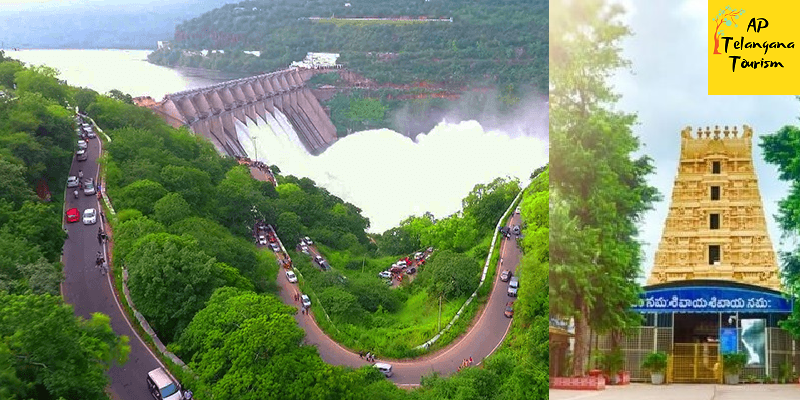
Srisailam Dam:
The Srisailam Dam is constructed across the Krishna River in Kurnool district, Andhra Pradesh near Srisailam temple town and is the 2nd largest capacity working hydroelectric station in the country. The dam was constructed in a deep gorge in the Nallamala Hills in between Kurnool and Mahabubnagar districts, 300 m (980 ft) above sea level. It is 512 m (1,680 ft) long, 145 metres (476 ft) maximum height and has 12 radial crest gates. It has a reservoir of 616 square kilometres (238 sq mi). Project has an estimated live capacity to hold 178.74 Tmcft at its full reservoir level of 885 feet (270 m) MSL.
The Srisailam project began in 1960, initially as a power project. After several delays, the main dam was finally completed twenty years later in 1980 July 26. In the meantime the project was converted into a multipurpose facility with a generating capacity of 770 megawatts (1,030,000 hp) by its second stage which was completed in 1987.
At present the initial inflows into Srisailam reservoir are stored excessively without using for power generation. The flood water fills the remaining empty Srisailam reservoir quickly and most of the flood water overflows into downstream Nagarjunasagar reservoir without being used for power generation. The endeavor shall be to fill the Nagarjunasagar reservoir fully with the uniform water released through the power generating units.
Best Tourism Places near Srisailam: Awesome Tourist Places near Srisailam You must visit
Nagarjuna sagar-Srisailam Tiger Reserve:
Nagarjunsagar-Srisailam Tiger Reserve is the largest tiger reserve in India . The reserve spreads over five districts, Kurnool District, Prakasam District, Guntur District, Nalgonda District and Mahbubnagar district. The total area of the tiger reserve is 3,728 km2 (1,439 sq mi). The core area of this reserve is 1,200 km2 (460 sq mi). The reservoirs and temples of Srisailam are major attraction for many tourists and pilgrims. It is the largest tiger reserve forest in India.
This reserve is located between longitude: 78°30′ to 79°28′ east and latitude: 15°53′ to 16°43′ north. Elevation varies from 100 m (330 ft) to 917 m (3,009 ft) above mean sea level.
Average annual rainfall is 1,000 mm (39 in).The hill ranges contain a number of plateaus, of which, Amrabad, Srisailam, Peddacheruvu, Sivapuram, and Nekkanti are noteworthy. Nagarjunasagar receives rains from the southwest monsoon, which is active from the second half of June to the end of September. The Krishna river cuts its basin almost 200 m (660 ft) deep over a distance of 130 km (81 mi) through the reserve. There are several waterfalls in the reserve such as the Ethipothala Falls, Pedda Dukudu, Gundam and Chaleswaram.
The ancient temples at Srisailam of Lord Mallikarjuna and his consort goddess Bhramaramba, an incarnation of Parvathi as the fair-complexioned boon from Brahma, contain one of the twelve sacred Shaiva Jyotirlingas and one of the eighteen Maha Shakthi peethas in India.
This area contains ruins of Nagarjuna Viswa Vidyalayam. The site was once the location of many Buddhist universities and monasteries.
The ruins of a fort of the 3rd century BCE Indian ruler, Ikshwaku Chandragupta overlook the Nirjivapuram (Lifeless city) valley. The ancient fort of king Pratap Rudra of the Kakatiya dynasty and several other forts are visible on the banks of the Krishna River. An ancient 105 mi (169 km) wall constructed there by the Kakateeyas is an impressive historic feature.
This area contains several rock shelters and cave temples including: Akka Mahadevi Bhilam, Dattatreya Bhilam, Umaa Maheswaram, Kadalivanam, and Palankasari.
Flora:
The main types of forest biomes in the reserve are: southern tropical dry mixed deciduous forest, Hardwickia forest and Deccan thorn scrub forests with much Euphorbia scrub. Important plant species here are: Anogeissus latifolia (axlewood), Cleisthanthus collinus (odcha), Terminalia spp., Pterocarpus marsupium, Hardwickia binata (anjan tree), Boswellia serrata (Indian frankincense or salai), Tectona grandis (teak), Mundulea sericea and Albizia spp. (silkplants).
Fauna:
The main mammals in the reserve are: Bengal tiger, Indian leopard, sloth bear, Ussuri dhole, Indian pangolin, chital, sambar deer, chevrotain, blackbuck, chinkara and chowsingha. Lesser fauna include mugger crocodile, Indian python, Indian Cobra, Ptyas mucosa, Bengal monitor, Indian Star tortoise and Indian peafowl.[2] Endemic reptiles like the skinks Ashwamedh writhing skink, Sharma’s mabuya] lizards and the Nagarjun Sagar racer snake are particular highlights of this unique region.
Nallamala Forest:
Nallamala Forest is located in the Indian state of Andhra Pradesh and Telangana. It is part of the Eastern Ghats.
The Nallamalas (also called the Nallamalla Range) are a section of the Eastern Ghats which stretch primarily over Kurnool, Nellore, Guntur, Prakasam, Kadapa and Chittoor districts of the state of Andhra Pradesh and Mahabubnagar, Nalgonda districts of the state of Telangana, in India. They run in a nearly north-south alignment, parallel to the Coromandel Coast for close to 430 km between the rivers, Krishna and Pennar. Its northern boundaries are marked by the flat Palnadu basin while in the south it merges with the Tirupati hills. An extremely old system, the hills have extensively weathered and eroded over the years. The average elevation today is about 520 m which reaches 1100 m at Bhairani Konda and 1048 m at Gundla Brahmeswara.[1] Both of these peaks are in a north westerly direction from the town of Cumbum. There are also many other peaks above 800m.
The rocks of the Nallamala ranges belong to the Kadapa system which is a series some 20,000 ft. thick.[3] The primary rocks are Quartzite overlaid with an irregular slaty formation. Some sandstone is also to be found. The rocks here are very irregular and soft in texture thus rendering commercial exploitation impossible. These rocks are among the oldest in the world and have been formed as a result of large scale volcanic activity hundreds of millions of years ago. The evidence of the volcanic forces are evident in the foldings into which the rocks have been forced.
The Nallamalas have a rather warm to hot climate throughout the year. Rainfall averages about 90 cm and is concentrated in the months of the South West Monsoon (June–September). The fissured rocks prevent any water from percolating underground and hence most of the discharge runs off as mountain streams to join the Gundlakamma River, the largest river to arise in these hills. Winters are mostly cool and dry with the average temperature around 25 degrees Celsius.Summers are very hot,with temperatures as high as 45 degrees celcius.
These hills are almost completely covered with open jungle. Lack of water prevents the growth of large trees and the prevalent vegetation consists of Terminalia, Hardwickia and Pterocarpus. Agriculture is almost non existent apart from isolated patches near villages where subsistence farming is practiced. The Nallamala Forests are probably the largest stretch of undisturbed forest in South India apart from the Western Ghats and were particularly rich in game till the 1970s. A large part of the forest is a part of the Nagarjunsagar-Srisailam Tiger Reserve that has a viable tiger population. Leopard sightings too are not uncommon. Many of the adventures of the popular wildlife writer, Kenneth Anderson are set in these forests. The uneven terrain and the scarcity of water has prevented the growth of any large cities in this region. Kurnool is the largest city in this region with Nandyal being the second largest and little nearer than Kurnool to the forest. The indigenous population consists of the Chenchus, a forest dwelling tribe who have remained cut off from the modern world even today. Farming is the primary occupation of the people in the plateaus while the Chenchus are still hunter gatherers. The hills were a hotbed of Naxal activities until recently. Police action since 2005 has all but cleared the forest of them.
Transport:
A state highway and the Nallapadu-Nandyal line of the Guntur railway division pass through the hills. The railway was first built by the Madras and Southern Mahratta Railway and is a feat of engineering, having 2 tunnels at Bogada and Chelama and a few viaducts, the most famous being the now abandoned Dorabavi Viaduct. The railway enters the hills at the Nandikama Pass near Cumbum Lake. The highway follows a zig zag alignment and thus avoids any tunnels. The primary exports of this region are forest produce like timber waste, honey and molasses.
Srisailam on the River Krishna is the site of a large hydroelectric power project as also an ancient temple dedicated to Lord Shiva. Mahanandi temple and Ahobilam Nava Narsimha Temples are situated here. A stream descends down the Gundla Brahmeswara peak and ends in a waterfall and sacred pool called Nemaligundam (Peacock Pool). The Mallela Theertham waterfall on the river Krishna is also located in this forest.
The Cumbum Lake is one of Asia’s oldest man made lakes and dates back to the 15th century. It was built by the Gajapati kings of Orissa for irrigating about 420 km2 farmland by damming a narrow opening between two adjoining hills and later renovated by queen Vardarajamma of Vijayanagara kingdom in the 16th Century.
Ahobilam:
Ahobilam is a village and holy site in the Allagadda mandal of Kurnool district in the Indian state of Andhra Pradesh. It is surrounded by picturesque hills of the Eastern Ghats with several mountain hills and gorges. It is the centre of worship of Narasimha, the lion-headed avatar of Vishnu, to whom the nine Hindu temples and other shrines all dedicated. The main village and a temple complex are at Lower Ahobilam. Upper Ahobilam, about 8 kilometres to the east, has more temples in a steep gorge.
The temple consists of nine shrines to Narasimha, located around a 5 KM circle. In addition to the nine shrines, there is a temple for Prahaladavarada Varadhan in the foothills of the mountain. Due to security reasons and the difficulty in performing daily worship, many of the utsava vigrahas of the nine shrines are kept in this temple. To visit the entire group still involves some relatively arduous walking.
The main Narashima temples at each site were built or expanded by the kings of Vijayanagara in the 15th and 16th centuries, then sacked by the Mughals in 1578, then restored and expanded at various times, up to the present day. As they stand, they are a mixture of work from all these periods.
Ahobilam is traditionally regarded as the place where Vishnu in the form of Narasimha killed the rakshasa Hiranyakashipu in order to save his devotee Prahlada. The legend says that Narasimha emerged from a rock pillar to kill the rakshasha. The moment is represented in a number of murti in the various temples. Also, Garuda prayed for a vision of Narasimha in the form of Avathara, to fulfil his wish, and settled in nine forms across the hills in Ahobilam. Ahobilam is located at 15.1333°N 78.7167°E. It is located in Nallamala Forest, along the Eastern Ghats.
Mahanandi:
Mahanandi, is a village located east of the Nallamala Hills near Nandyal, Kurnool District, Andhra Pradesh, India. It is surrounded by forests. Within 15 km of Mahanandi, there are nine Nandi shrines known as Nava nandulu. Mahanandi is one of the Nava Nandis. The Mahanandiswara Swamy Temple, an important shrine, is located here. This ancient temple dates back over 1,500 years. The inscriptions of 10th century tablets speak of the temple being repaired and rebuilt several times.
These nine temples are Mahanandi, Shivanandi, Vinayakanandi, Somanandi, Prathamanandi, Garudanandi, Suryanandi, Krishnanandi (also called Vishnunandi) and Naganandi.
A festival is held here annually during February and March to celebrate Maha Shivaratri, the Great Night of Shiva.
Mahanandi is about 21 km from Nandyal. The nearest airport is at Hyderabad, which is about 215 km from Kurnool, and the nearest railway station is at Nandyal. There are 2 routes to reach Mahanandi from Nandyal town. One route via Thimmapuram and is the shortest, around 17 km from bus stand. Another route, via giddalur road you need to take left diversion at Boyalakuntla cross and it will be around 24 km distance from nandyal.
The temple is famous for its fresh water pools, called Kalyani or Pushkarni. The architecture of the temple shows the strong presence of the Chalukya Kings in this region. The pools of temple shows the skill of the Vishwakarmas.
The main temple is surrounded by three pools: two small pools at the entrance and one big pool inside the temple itself. This holy tank is 60 square feet (5.6 m2) with an outdoor pavilion called a mandapa in the centre. The inlets and outlets of the tank are arranged so that the depth of the water is constantly kept at five feet, thus enabling pilgrims to bathe in the holy waters. Bathing in the inside big pool is prohibited after 5 PM every day.
A peculiarity of the water source is that it has a constant flow irrespective of the change of seasons. The water source originates at the Garbhagruha (inner shrine) just below Swayambhu Linga. One can touch the water near the Shiva Linga (symbol of Shiva). The devotees can offer prayers and touch the Shiva Linga. This is unusual, because traditionally at temples, the main deity is kept away from the touch of the devotees.
The water is famous for its crystalline and healing qualities and is ever tepid. The outgoing water irrigates 2,000 acres (8.1 km2) of fertile land surrounding the village. The surrounding areas are under production with rice fields, fruit, vegetable and flower gardens.The temple is well known for the konneru. The water during the winter season will be very hot and vice versa during the summer. During the early mornings, the water is lukewarm and water gets cooled gradually with the rise in temperature.
Mallela Theertham: Telangana
Mallela Theertham is a waterfall located in the Nallamala Forest in Nagarkurnool, Telangana, India.[1] The River Krishna flows through this forest. It is located around 58 km from Srisailam and 185 km from Hyderabad.
Mallela Theertham is in the middle of the dense forest. A walk down 350 steps is required to access the waterfall.The best flows are from the months of October to February. March to June is the dry season. The remaining months are rainy months, and it is very difficult to drive on the muddy road. The water comes from a small rivulet and from this area, it flows through the dense jungle and then meets the Krishna RiverThis place is near to Achampet.
It is said that many sages have performed penances there for Shiva and Shiva has himself appeared there to many of his devotees. It is believed that many tigers visit there to drink water during summer.
Guntur Tourism | Tourism Places and Travel Guide of Guntur
Tourism of Guntur and Guntur Tourism Places to Visit:
Guntur is a city and the administrative headquarters of Guntur district in the Indian state of Andhra Pradesh. Guntur city is the 24th most densely populated city in the world and 11th in India.It is situated 40 miles (64 km) to the north of the Bay of Bengal, on the Eastern Coastal Plains. The city forms a part of the Andhra Pradesh Capital Region, administered by APCRDA.It is a municipal corporation and also the headquarters of Guntur East and Guntur West mandals in Guntur revenue division.
As of 2011 census of India the city is the third most populous in the state with a population of 743,354.Guntur is classified as a Y-grade city as per the Seventh Central Pay Commission.[10] It forms a part of Visakhapatnam-Guntur Industrial Region, a major industrial corridor in the country. The city is known for its chilli, cotton and tobacco exports and has the largest chilli market yard in Asia.
Guntur is located at 16.29°N 80.43°E. It has an average elevation of 33 m (108 ft) and is situated on the plains. There are few hills in the surrounding suburban areas and Perecherla Reserve Forest on the north west. The city is around 40 miles (64 km) to the west of the Bay of Bengal on the east coast of India. The Krishna delta lies partly in the Guntur district. There are other smaller rivers and channels in the region such as Guntur Channel, Chandravanka, Naagileru, Guntur Branch Canal etc.
The city has many parks, museums, temples, nature conservation sites, forts, resorts and caves. The Jinnah Tower is one of the iconic structure on Mahatma Gandhi Road, one of the important center of the city. There are seventeen parks in the city with some of them maintained by the municipal corporation.Larger city parks like Nagara-Vanam are being developed on the outskirts of the city.There are many places to visit near by the city such as Uppalapadu Bird Sanctuary, Kondaveedu Fort etc. There are many festivals and events in the region such as beach festivals, hill festivals attract the city residents during various festival seasons. The closest beach to the city region is Surya Lanka
Jinnah Tower:
Jinnah Tower is a landmark monument in the city of Guntur in Andhra Pradesh. It is named after the father of Pakistan, Muhammad Ali Jinnah and is located on Mahatma Gandhi Road of the city as a symbol of peace and harmony. The tower was erected on six pillars which open to a dome, typical of the then Muslim architecture in early twentieth century. The tower is currently in a state of neglect and crumbling. According to the State Archaeology Department, the tower could be brought under the list of protected monuments if it has history of more than 60 years.
Uppalapadu Bird Sanctuary:
The Uppalapadu Bird Sanctuary is located in Uppalapadu, near Guntur City, India. Painted storks, spot-billed pelicans and other birds that migrate from various countries such as Siberia and Australia use the village water tanks for nesting.
The bird population in these tanks used to be around 12,000 previously, however lately only about 7000 birds roost in this dwindling habitat through the year. But some initiatives have taken place such as adding artificial trees, local awareness, proper water supply to the ponds etc. The number of Pelicans, may be more than 1500.
Besides this 6 pintail ducks a few cormorant 5 red crested pochard(rhodonesa rufina), common coot, common teal, black-headed ibises, 2 stilts were also sighted. Instead of erecting wire mesh artificial-trees the forest department should plant more Prosopis velutina tree in and around this swamp.
The ibises and painted stork were found scavenging on the left over rotten fish droppings of pelican along with jungle crow. The main diet being fed to the chicks was both fresh and sea water fish. Some of the fish, particularly LabeoRohita (Carp) and other sea fish, which had dropped from the nests, were fresh and about 0.8 kg in weight. They must have been brought from nearest river and sea which is about 20–30 km away from the site since the pelicans were not found fishing from nearby ponds.
In 2009 the large wire mesh trees which were provided by the Forest department are being used for nest making by the pelicans, although they did not do so in the initial years. This pelicanary has completed ten years operation in 2009. Some pelicans have now opted to use another pond at Ramchandrapalem which is about 4 km from this site towards Guntur.
Kondaveedu Fort:
Kondaveedu Fort is a historically significant ancient hill fortress located in Kondaveedu, a village in the Chilakaluripet constituency of Guntur district, Andhra Pradesh, India. The site is located 16 miles west of the city of Guntur. Apart from this main fort, there are two other forts nearby. Efforts are in progress to classify Kondaveedu Fort as a UNESCO World Heritage Site.
Kondaveedu Fort was constructed by Prolaya Vema Reddi. It was used as the capital by the Reddi dynasty between 1328 and 1482, shifting from their former capital at Addanki. It was taken by the Vijayanagara emperor Krishnadevaraya in 1516. The Golconda Sultans fought for the fort in 1531, 1536 and 1579, and Sultan Quli Qutb Shah finally captured it in 1579, renaming it Murtazanagar.
The fort came under the control of the French colonists in 1752 when it was extensively fortified. It passed on to the British East India Company who got control of the fort in 1788 but abandoned it in the early 19th century in favour of Guntur. Now, the massive fortifications and battlements are seen in ruins only. The interior has extensive ruins of magazines and storehouses.
The fortresses were once the capital of the Kondavidu Reddi Kingdom that was delimited between the south of the Krishna River and the Gundlakamma River and located 8 miles (13 km) to the west of Guntur city. They were erected on a high ridge of a small range of hills with average elevation of 1,500 feet (460 m) (highest point on the ridge is 1,700 feet (520 m)). There are two hill (ghat) sections, which form the hill ranges, one is to the north, which provides a very steep but short access to the forts. The preferred access is more circuitous and less tiring and involves 2 miles (3.2 km) of trekking. Kondaveedu and the surrounding forest areas have a large number of Custard apple trees.
The village of Kondavidu is said to have been established in 1115 CE as a fortified township by Gopanna, a commander of Buddhavarma of the Telugu Choda dynasty. Later it came under the Kakatiyas and occupied by Prolaya Vema Reddi (r. 1325–1353) who shifted his capital from Addanki to Kondaveedu. Later, the fort was under the control of Vijayanagar Kings, Gajapatis, Golkonda sultans and lastly under French and British.
In 1323, Warangal and the whole of Andhra Pradesh came under the reign of Tughlaqs, rulers of Delhi. Their depredations and despotic reign resulted in the formation of a confederation movement by the Hindu Musunuri Nayaks who ousted the Muslims from Warangal, and the Reddys were part of this movement.
The Reddys of Kondaveedu were initially feudatories of the kings of Warangal. From inscriptions, it is inferred that their rule overlapped with that of the Korukonda Reddis and that they shifted from their earlier capital at Addanki in Guntur to Kondaveedu. The founder of the dynasty was Prolaya Vema Reddy, the son of Prola. They ruled in the region around present-day Vijayawada and Guntur towns for nearly a hundred years (1328–1428). Their first ruler Prolaya Vema Reddy (followed by five other rulers till 1428) who ruled till 1353, strengthened the defenses of his kingdom by building a number of forts, which included the Kondaveedu Fort. He shifted his capital from Addanki in Guntur to Kondaveedu fort. Subsequently, the region was ruled by the Bahmanis (1458), the Vijayanagara Kings (1516), the Qutb Shahis, (1531,1537 & 1579), the Mughal army of Aurangzeb in 1687, the French (1752), the Asafjahi Kings, and finally the British (1766 and 1788).
Early in 2019, remains of a Buddhist stupa were found under a dilapidated Hindu temple at Kondaveedu fort. The remains date back to the later Satavahana period — 1st to 2nd century CE. This discovery pushes back of the history of Kondaveedu to the Satavahana period.
Kondaveedu Fort is situated in Kondaveedu village west of Guntur City. It is about 25 kilometres (16 mi) from Guntur city and about 13 km from the side of Chilakaluripet. Guntur is easily accessible by road and rail from all parts of India. The nearest airport is Gannavaram Airport, which is 58 kilometres (36 mi) away from Guntur city. After reaching Guntur one should board a Guntur-Chilakaluripet ordinary bus and alight at Bhoyapalem-Pirangipuram Road and can hire an auto rickshaw to the fort.
The simplest way to reach the fort by one’s own vehicle. Reach Guntur or Chilakaluripet by road. Drive 25 km from Guntur towards Chilakaluripet via NH5 vice verse 13 km from Chilakaluripet and turn towards Bhoyapalem-Pirangipuram Road. In this road we need to travel around 10 km to our destination.
Suryalanka Beach:
Suryalanka Beach is a beach in Guntur District of the Indian state of Andhra Pradesh. It is located 50 miles south of Guntur City near Bapatla. The place has many resorts close to the beach
Pedakakani Dargah:
Pedakakani is a village in the Guntur district of the Indian state of Andhra Pradesh. It is located in Pedakakani mandal of Guntur revenue division. Hindu shrine of Shiva, Sri Bhramaramba Malleswara Swamy Temple is located in the village. Peddakakni is united with all major cultures. Ancient Sri Malleswara Swami vari Devastanam, Baji Baba Darga, Kakani Thota is located here. Also Parantallamma temple is located here.
Mangalagiri Lakshmi Narasimha Temple:
Lakshmi Narasimha Temple is a vaishnavite temple and one of the eight sacred places of Lord Vishnu in India. It is situated at the foot of the Auspicious Hill in Mangalagiri of Guntur district of Andhra Pradesh. It is one of the temple in the series of three temples located on and at the bottom of the hill, the other two being Panakala Narasimha Temple on the hill and Gandala Narasimha Temple at the top of the hill. It has one of the highest gopurams in South India and only one of its type in this part of India. It is 153 feet (47 m) in height and 49 feet (15 m) wide and has eleven storeys
Tourism of Arasavalli – Arasavalli Sun Temple | AP Tourism
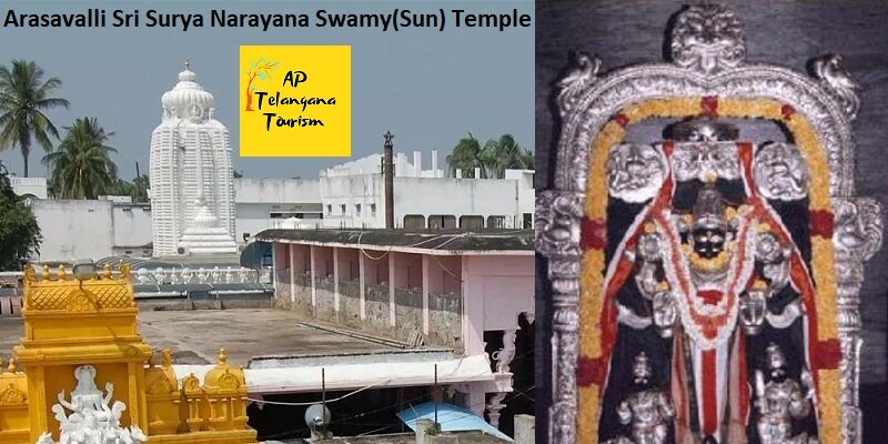
Tourism of Arasavalli – Arasavalli Sun(Sri Surya Narayana Swamy) Temple
Arasavalli is famous for it’s kind of unique Temple of Surya Bhagawan(Sri Surya Narayana Swamy Temple). There are two big temples of Sun that one is in Konark, Odisha and another one is Arasavalli, Andhra Pradesh. The specialty of Arasavalli Surya Bhagawan is that the first Sun rays are directly fall on the Idol of Surya Narayana Swamy. Arasavalli is an outgrowth of Srikakulam municipality in Srikakulam district of the Indian state of Andhra Pradesh. It is located in Srikakulam Mandal of Srikakulam revenue division
Arasavalli Sun Temple which is dedicated to the Hindu solar deity Surya, located in this village. The original name Harshavalli means abode of joy. It is believed to have been built in the 7th Century AD by the Kalinga rulers Devendra Varma.
Arasavalli Sun Temple is a 7th-century AD Sun Temple at Arasavalli in Andhra Pradesh, India. It is situated in Arasavalli Village at a distance of 1 km east of Srikakulam Town. It is believed that the temple was built by king Devendra Varma, ruler of the Kalinga Dynasty. The temple is still being visited today and is one of the most popular tourist attractions in the town. This temple is considered as one of the oldest sun temples in India.
The Temple was dedicated to the Hindu sun god Surya. The walls in the temple are inscribed saying the creator of the temple was the ruler Devendra Varma, stating it was built in the time period known to them as the 7th century. The walls also state the temple was fixed and changed a bit to help with some of the sun temple´s major flaws during their 18th and 19th century. A lot of these changes were contributed by the Dusi family. Over the years the sun temple has been an important landmark for many of the festivals celebrated in the town. Including the important festival Rathasaptami.
The temple is very much recognized as a resemblance of magnificence and beauty. It takes in architectural skills of Vishwakarma Brahmins or Maharanas of Odisha. In the earlier parts of the day the temple is built to direct the sun´s light to fall on the feet of the lord Surya showing his importance and power.
Indra Pushkarini (Temple tank) at Arasavilli:
A sun Temple (or solar temple) is a building used for religious or spiritual activities, such as prayer and sacrifice, dedicated to the sun or a solar deity. Such temples were built by a number different cultures and are distributed across the world including in India, China, Egypt, Japan and Peru. Some of the temples are in ruins, undergoing excavation, preservation or restoration and a few are listed as World Heritage Sites individually or as part of a larger site, such as Konark, Arasavalli Sun Temples.
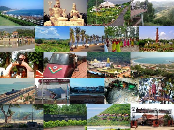
Araku Valley | The Tourism of Araku – AP Telangana Tourism
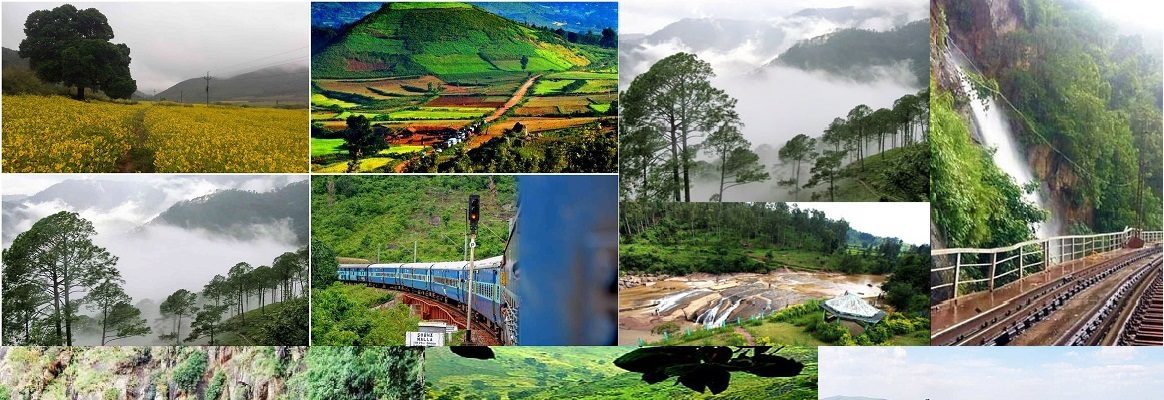
The Araku Tourism |Araku Valley – AP Telangana Tourism
Araku Valley:
Araku Valley is the most Favorite Tourism spot in Telugu States Andhra Pradesh, Telangana and neighborhood states like Odisha, Chhattisgarh, Jharkhand, West Bengal. It is famous for its scenic beauty of nature in eastern Ghats in AP. Majorly the Araku beauty of nature visible at it’s best in the rainy and winter seasons. Araku Valley Tourism is surrounded by most popular Tourism spots like Borra Caves, Waterfalls, Steams, Lambasingi, Eastern Ghats, Paderu Agency, Araku Town and Araku Valley Forest Journey through Road Trip and Train Journey.
Araku Valley is famous for at it’s best Appetite for Food Lovers like Bamboo Chicken (Traditionally called Bongulo Chicken or Bongu Chicken locally), Bamboo Biryani, and Chicken Cheekulu whic h is the tribal cuisine healthy food with great delicacy, if we try it once we never for get the taste of mouth watering food in our entire life. This is the great speciality of Araku Valley famous tribal special recipe Bamboo Chicken made with natural local process of woodfire and the chicken is marinated with Masala, pure natural spices that brought fromlocal forest. Araku Valley is famous a Hill station in Visakhapatnam district in the Indian state of Andhra Pradesh, lying 111 km west of Visakhapatnam city. This place is often referred to as Ooty of Andhra. It is a valley in the Eastern Ghats inhabited by different tribes.
Araku Tourism:
Araku Valley is a hill station and valley region in the southeastern Indian state of Andhra Pradesh. It’s surrounded by the thick forests of the Eastern Ghats mountain range. The Tribal Museum is dedicated to the area’s numerous indigenous tribes, known for their traditional Dhimsa dance, and showcases traditional handicrafts. A miniature train runs through Padmapuram Gardens, with its sculptures and tree-top huts.
Araku is located in the Eastern Ghats about 114 kilometres from Visakhapatnam, close to the Odisha state border. The Anantagiri and Sunkarimetta Reserved Forest, which are part of Araku Valley, are rich in biodiversity and are mined for bauxite. Galikonda hill rising to a height of 5,000 feet is amongst the highest peaks in Andhra Pradesh. The average rainfall is 1,700 millimetres, the bulk of which is received during June–October.The altitude is about 1300 m above the sea level. The valley spreads around 36 km.
Coffee was first introduced in Eastern Ghats of Andhra Pradesh in 1898 by British in Pamuleru valley in East Godavari district. Subsequently, it spread over to Araku Valley in the early 19th century. After independence, the Andhra Pradesh Forest Department developed coffee plantations in the valley. In 1956, Coffee Board appointed Andhra Pradesh Girijan Cooperative Corporation Limited (GCC) for promoting coffee plantations in the valley through local tribal farmers. In 1985, the plantations were handed to A.P. Forest Development Corporation and GCC promoted Girijan Coop. Plantation Development Corporation (GCPDC) exclusively to develop coffee plantations in tribal areas. All the plantations developed by GCC and GCPDC were handed over to the tribal farmers at two acres per family.
Araku Tourism Location area is connected through both rail and road to Visakhapatnam. Araku railway station is located on the Kothavalasa-Kirandul railway line of Visakhapatnam division of the East Coast Railway, on the Indian Railways network. RTC Buses to Visakhapatnam every half an hour.
Padmapuram Gardens:
Padmapuram Gardens is a tourist attraction in the Araku valley in Andhra Pradesh, India. The famed Padmapuram gardens are located in the beautiful and serene valley Araku. It is a short drive away from the railway station.
Borra Caves:
The Borra Caves, also called Borra Guhalu, are located on the East Coast of India, in the Ananthagiri hills of the Araku Valley with hill ranges’ elevation varying from 800 to 1,300 meters of the Visakhapatnam district in Andhra Pradesh. The caves, one of the largest in the country, at an elevation of about 705 meters, distinctly exhibit a variety of speleothems ranging in size and irregularly shaped stalactites and stalagmites. The caves are basically karstic limestone structures extending to a depth of 80 m, and are considered the deepest caves in India. The native name for the caves is Borra Guhalu. Borra means hole in Odia language and guhalu means caves in Telugu language.
Location of Borra Caves:
The caves are located in the Ananthagiri hills range of the Araku valley of the Visakhapatnam district in Andhra Pradesh. The caves are 448 kilometres from Bhubaneshwar in Odisha and 656 kilometres from Hyderabad, both via National Highway 5. The caves are well connected by road, rail and air services. The nearest international airport is Visakhapatnam Airport, 76 km from Borra Caves, which is 12 kilometres from the Visakhapatnam city center. Vishkapatnam is 90 km away by road. It is mostly a hill road and the journey takes about three hours.
Train services operate on the Kothavalasa-Kirandul railway line in East Coast Railway, Indian Railways. The train journey over a distance of 100 km from the Vishkapatanam railway station passes through Eastern Ghats hill section, which has 30 tunnels en route. The journey by train takes about five hours to the Railway Station near the caves called the Borra Guhalu Railway station.
Tourist Attractions Near Borra caves and Araku Valley:
Guided tours for a day trip to the Borra Caves cover interesting attractions like the Tyada Railway Tunnel, Damuku View Point, Ananthagiri Coffee Plantation, Padmapuram Gardens and the Araku Valley. For the benefit of the visitors, an information board at the entry point to the caves gives some details of the caves and its surroundings. An Arraku and Borra rail-cum-road package tour organized by the Andhra Pradesh State Tourism Department is available for visitors keen to see the Borra Caves.
A walk around the caves provides views of the mountainous area which is rich in flora and fauna. The Andhra Pradesh State Tourism Department has installed 26 mercury, sodium vapor and halogen electric lamps, which provide views of the formations. The Araku valley, a hill station about 29 km from the Borra Caves, is also a tourist attraction for people visiting the caves. November and December are ideal months to visit the caves.
Lambasingi: A Hot Tourism Spot near Araku Valley
Lambasingi or Lammasingi is a small village in the Eastern Ghats of Chintapalli Mandal of Visakhapatnam district in the Indian state of Andhra Pradesh. With an altitude that of 1000 m above sea level, the area is cooler than the surrounding plains and is covered in moist deciduous forest cover. There are several coffee, pine, and eucalyptus plantations around the area and some small attempts to grow apple and strawberry.
The region was formerly densely covered in forests and known in the past to have supported tigers. The large wildlife in the region includes gaur. The region is known for its diversity of bird life which were studied by numerous ornithologists.
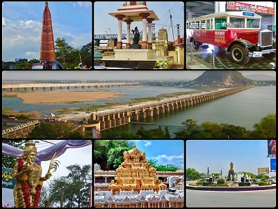
Tirumala Tirupati Tourism – AP Tourism
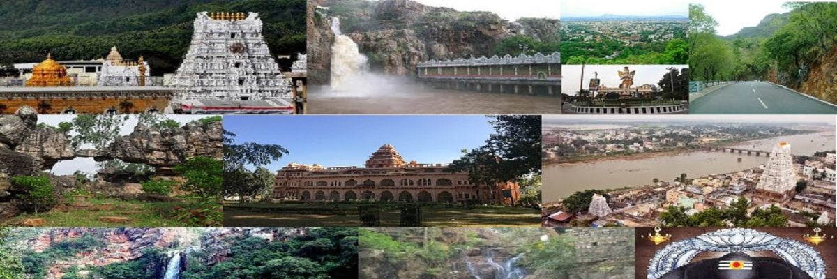
Tirumala Tirupati Tourism News Updates Online – AP Telangana Tourism:
Tirumala Tirupati is a Historical Pilgrimage Tourism Tourist Place in Tirupati, Chottoor District, Andhra Pradesh, India. Tirumala Tirupati Tourism is famous for many temples which are Worldwide famous and most populous visiting Tourism spot in India with huge floating over 365 days with highest footfalls. The Places like Tirumala Tirupati Devasthanam, Sreekalahasteeswara Temple, Kanipaka Varasiddi Vinayaka Temple, Alivelu Mangapuram, Papavinasam, Akasa Ganga, Kapila Theertham, Chakra Theertham, Tumburu Theertham, Talakona Forest and Waterfalls, Sri Venkateswara National Park, Chandragiri Fort, Srivari Padalu, Alipiri are the most Popular Tirupati Tourism Places in Andhra Pradesh(AP) Tourism.
Tirupati is a city in the Indian state of Andhra Pradesh. Its Sri Venkateswara Temple sits atop one of the the 7 peaks of Tirumala Hills, attracting scores of Hindu pilgrims. Sri Venkateswara National Park, home to the temple, also contains the Sri Venkateswara Zoological Park with lions and primates. Nearby, next to a waterfall and cave believed to be sacred, Sri Kapileswara Swamy Temple is dedicated to Lord Shiva.
Tirupati is a city in Chittoor district of the Indian state of Andhra Pradesh. The city is home to most famous and important Vaishnavite shrine of Tirumala Venkateswara Temple and other historic temples and is referred to as the “Spiritual Capital of Andhra Pradesh”. It is one of the seven Swayam vyaktha kshetras dedicated to Vishnu.
Tirupati is a municipal corporation and the headquarters of Tirupati mandal, and of the Tirupati revenue division. As of 2011 census, it had a population of 287,588, making it the ninth most populous city in Andhra Pradesh. It is the seventh most urban agglomerated city in the state, with a population of 459,985. Tirupati is home to many educational institutions and universities. For the year 2012–13, India’s Ministry of Tourism named Tirupati as the “Best Heritage City”. Tirupati has been selected as one of the hundred Indian cities to be developed as a smart city under Smart Cities Mission by Government of India.
Venkateswara Swamy Temple, Tirumala Tirupati Devasthanam:
Venkateswara Temple is a landmark Vaishnavite temple situated in the hill town of Tirumala at Tirupati in Chittoor district of Andhra Pradesh, India. The Temple is dedicated to Venkateswara, a form of Vishnu, who is believed to have appeared here to save mankind from trials and troubles of Kali Yuga. Hence the place has also got the name Kaliyuga Vaikuntham and the Lord here is referred to as Kaliyuga Prathyaksha Daivam. The temple is also known by other names like Tirumala Temple, Tirupati Temple, Tirupati Balaji Temple. Venkateswara is known by many other names: Balaji, Govinda, and Srinivasa.
Tirumala Hills are part of Seshachalam Hills range. The hills are 853 metres above sea level. The Hills comprises seven peaks, representing the seven heads of Adisesha. The temple lies on the seventh peak -Venkatadri, on the southern banks of Sri Swami Pushkarini, a holy water tank. Hence the temple is also referred to as “Temple of Seven Hills”. Tirumala town covers about 10.33 sq mi in area.
Tiruchanur:
Tiruchanur (also known as Alamelu Mangapuram, Chirtanur) is a census town in Chittoor district of the Indian state of Andhra Pradesh. It is the mandal headquarters of Tirupati mandal. It forms a part of Tirupati urban agglomeration. The town is a religious destination for Hindu pilgrims due to the presence of Padmavathi Temple.
Tiruchanoor formed a part of Tiruvenkatam under the rule of Pallavas and was a part of Rajendra Cholamandalam, under the Cholas. It is originally called as AlaruMeluManga Puram as we see from Thousands of Inscriptions in and around Tirupathi, much later corrupted to Alamelu Mangapuram Hence, it got the name as Alamelu Mangapuram.
Alamelu mangapuram is located about 4 km from Tirupati central bus station and Tirupati Main. Tiruchanur provides rail connectivity and is one of the satellite railway station for Tirupati, which is under process of upgradation to a B category station.
The Seven Hills:
The temple is located on seven hills. The presiding deity is also referred to as Sapthagirisha or Lord of Seven hills. It is believed that seven hills, also referred to as Sapthagiri, represent the seven hoods of Adisesha. The seven hills are as follows:
- Vrushabhadri—Hill of Nandi, the vahana of Shiva and Incarnation of Vishnu.
- Anjanadri—Hill of Hanuman.
- Neeladri—Hill of Neela Devi.
- Garudadri or Garudachalam—Hill of Garuda, the vahana of Vishnu.
- Seshadri or Seshachalam—Hill of Sesha, the dasa of Vishnu.
- Narayanadri—Hill of Narayana. Srivari Padalu are located here.
- Venkatadri—Hill of Venkateswara.
Kapila Theertham:
Kapila Theertham is a famous Saivite Temple and Theertham, located at Tirupati in the Chittoor District of Andhra Pradesh, India. The idol is believed to be installed by Kapila Muni and hence Lord Siva here is referred to as Kapileswara.
There many other Most Important visiting places in Tirumala Tirupati and it’s Sourroudings like Papa Vinasam, Akasa Ganga, Chakra Theertham, Tumburu Theertham, Srivari Padalu, Alipiri.
Kalyana Venkateswara Temple, Srinivasamangapuram:
Sri Kalyana Venkateswara swamy Temple is an ancient Hindu Vaishnavite temple located at Srinivasamangapuram which is 12 km from Tirupati in Chittoor District of Andhra Pradesh, India. The temple is dedicated to Lord Venkateswara, a form of Vishnu and is referred to as Kalyana Venkateswara. The temple is categorised as an Ancient monument of National importance by Archaeological survey of India. It is one of the centrally protected monuments of national importance.
Srikalahasteeswara Temple:
Srikalahasti Temple is located in the town of Srikalahasti, in the state of Andhra Pradesh, India. It is one of the most famous Shiva temples in South India, and is said to be the site where Kannappa was ready to offer both his eyes to cover blood flowing from the Siva linga before the Siva stopped him and granted him mukti.
Vinayaka Temple, Kanipakam:
Vinayaka Temple or Sri Varasidhi Vinayaka Swamy Temple is a Hindu temple of Ganesha. It is located at Kanipakam in Chittoor district of Andhra Pradesh, India. The temple is about 11 km from Chittoor and 68 km from Tirupati.
Sri Venkateswara National Park:
Sri Venkateshwara National Park is a national park and biosphere reserve in Tirupati, Andhra Pradesh, India. The total area of the park is 353 km2. The park is known for its many waterfalls including the Talakona, Gundalakona and Gunjana. As the government of India declared the Seshachalam Hills as one of the biosphere reserves of India in 2010, this national park becomes the part of it.
Talakona Forest and Waterfall:
The Talakona Forest and Waterfall is in Sri Venkateswara National Park, Chittoor District of Andhra pradesh in India. With a 270 feet (82 m)-fall, Talakona is the highest waterfall in the Andhra pradesh state.[1] Talakona is also known for the Lord Siddheswara Swamy Temple, which is located close to the waterfall.
Chandragiri Fort:
Chandragiri is a town in Chittoor district of the Indian state of Andhra Pradesh. It is the mandal headquarters of Chandragiri mandal in Tirupati revenue division. It also falls in the jurisdictional limit of Tirupati Urban Development Authority.
Chandragiri is now famous for the historical fort, built in the 11th century, and the Raja Mahal (Palace) within it. The fort encircles eight ruined temples of Saivite and Vaishnavite pantheons, Raja Mahal, Rani Mahal and other ruined structures.
AP Tourism – The Tourism of Andhra Pradesh
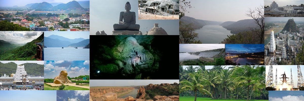
Tourism in Andhra Pradesh:
Andhra Pradesh is a state in India. Andhra Pradesh is situated in Eastern part of India. Andhra Pradesh comprises two regions likely Coastal Andhra and Rayalaseema. The State of Andhra Pradesh is well known for Coastal Region located at seabed with 9 districts and other 4 districts are into Rayalaseema.
It has a total of 13 districts, nine in Coastal Andhra Region and four in Rayalaseema Region. Coastal Andhra Region has occupied with Srikakulam, Vizianagaram, Visakhapatnam, East Godavari, West Godavari, Krishna, Guntur, Prakasam, Nellore Districts. The Rayalaseema Region has occupied with Anantapur, Chittoor, Kadapa, Kurnool Districts.
Andhra Pradesh has a coastal Belt of 974 km (605 mi) which is the second-longest coastline among the states of India, after Gujarat – with jurisdiction over almost 15,000 km2 of territorial waters.
The Tourism in Andhra Pradesh, describing the state as the Koh-i-Noor of India. Andhra Pradesh has a variety of tourist attractions including beaches, hills, caves, wildlife, forests and temples.
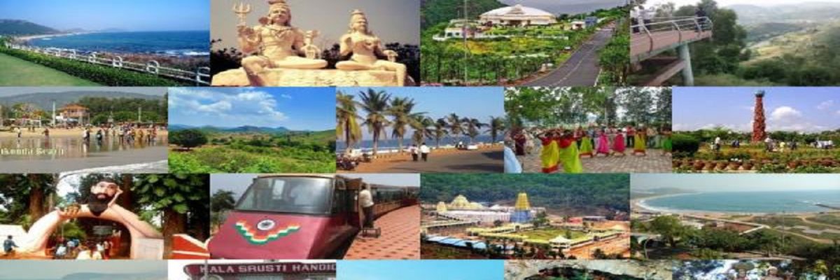
The Tourism of Andhra Pradesh likely to represent the Tirumala Venkateswara Temple in Tirupati is one of the world’s most visited religious sites, with 18.25 million visitors per year. Other pilgrimage centres in the state include the Mallikarjuna Jyotirlinga at Srisailam, the Srikalahasteeswara Temple at Srikalahasti, the Varaha Lakshmi Narasimha temple, Simhachalam at Visakhapatnam, the Ameen Peer Dargah in Kadapa, the Mahachaitya at Amaravathi, the Kanaka Durga Temple in Vijayawada, and Prasanthi Nilayam in Puttaparthi. The state’s natural attractions include the beaches of Visakhapatnam, hill stations such as the Araku Valley and Horsley Hills, and the island of Konaseema in the Godavari River delta.
Andhra Pradesh Tourism received a total of 194.8 million domestic tourists in 2019, which is the fourth highest in terms of domestic visitors by making it the third most-visited state in India.
Vijayawada Tourism | Tourism of Vijayawada(Bezawada), AP

Vijayawada Tourism | Tourism of Vijayawada(Bezawada), Andhra Pradesh
Vijayawada City Tourism: The Tourism of Bezawada
Vijayawada (formerly known as Bezawada) is a city in the Indian state of Andhra Pradesh. It lies on the banks of River Krishna surrounded by the hills of Eastern Ghats known as Indrakeeladri Hills in Krishna District. It geographically lies on the center spot of Andhra Pradesh. The city has been described as the commercial, political, educational and media capital of Andhra Pradesh, also the 42nd largest city in India and is one of the rapidly growing urban areas in India. It is considered to be a sacred place for residing one of the most visited and famous temples of Andhra Pradesh and India, Kanka Durga Temple of Hindu Goddess Durga. It also serves as the ritual host of Pushkaram (a river worshipping ritual in Andhra Pradesh and India) of River Krishna. Its railway station stands as one of the ten most busiest railway junctions in India. There is a legend which says that Arjuna, one of the heroes of the Indian epic Mahabharata, prayed on top of the Indrakeeladri Hill in the city and won the blessings of Lord Shiva to get the Pashupatastra to win the Kurukshetra War. It was called Vijayavatika (meaning Land of Victory in Telugu) when Goddess Durga killed the demon Mahishasura and rested on the Indrakeeladri Hill by the River Krishna establishing the victory over evil hence the place got its name Vijayavatika, “Vijaya”- meaning victory and “Vatika” meaning Place or land in Telugu. Over the years Vijayavatika name changed to Rajendra Chola Pura during Chola Dynasty and Bezawada during British rule and eventually to Vijayawada.
The city is also the third most densely populated urban built-up areas in the world. and is classified as a Y-grade city by the Sixth Central Pay Commission. The city is the second most populous in the state with a population of more than one million. It was recognised as a “Global City of the Future” by McKinsey Quarterly, which expected an increase to GDP of $17 billion by 2025. In October 2018, it was awarded with ISO 37120 platinum level certification and has been added to the “Global Cities Registry”.
Due to the presence of several well-known educational institutions, the city has emerged as a major educational hub in recent times, with many of nationwide students studying in the city. It is expected to be the India’s 10th fastest growing economy in the world by 2035, a report published by Oxford Economics. Due to its rating highly in entertainment, construction, food as well as education, health care, transport, It is ranked as India’s ninth most liveable city as per Ease of Living Index 2018, Ministry of Housing and Urban Affairs and 2nd most liveable city in the state of Andhra Pradesh.
The city has an airport at Gannavaramrecently new terminal was opened . The Vijayawada Junction railway station is one of the busiest in the country.
Toponomy:
There are many legends behind the origin of the name Vijayawada. Goddess Durga killed Mahishasura and relaxed at this place. As she was victorious, the place came to be known as Vijayawada (vijaya translates to victory and wada as place, literally meaning The Place of Victory). The hill was called as Indrekeeladri since it was frequently visited by Indra and his affiliates. The epic Mahabharata refers to the Indrakiladri hills as the place where Arjuna secured Pashupatastra from Shiva. One of the names of Arjuna is “Vijaya”(invincible). Thus city thereafter came to be known as Vijayavatika (‘Vatika’ translates to place in Telugu) and later as Vijayawada.
In some legends, Vijayawada was referred to as Rajendracholapura as Virarajendra Chola won a battle against Chalukyas in 1068 and ruled over this place. A tale behind its acquiring the name Bezawada is that Goddess Krishnaveni (River Krishna) requested Arjuna to make a passage for her to merge into the Bay of Bengal. Hence, Arjuna made a bejjam (hole) through the mountains and the place came to be known as Bejjamwada which later changed to Bezawada. Other names of Vijayawada were being Vijayavata, Beejapuram, Kanakaprabha, Kanakapuram, Kanakawada, Jayapuri, Vijayapuri, Phalguna Kshetram & Jananathpura.
History:
Bezawada (as Vijayawada was known then) was founded around 626 A.D. by Paricchedi Kings. Vijayawada history reveals that Bezawada (Vijayawada) was ruled by King Madhava Varma (one of the kings of Vishnukundina dynasty). Chinese Buddhist scholar Xuanzang stayed a few years in Bezawada (Vijayawada) in around 640 A.D. to copy and study the Abhidhamma Pitaka, the last of the three pitakas (Pali for baskets) constituting the Pali canon, the scriptures of Theravada Buddhism.
Mogalrajapuram hills have five rock-cut temples, built during the 4th–9th centuries. Some of the caves can be attributed to Vishnukundina dynasty. Akkana Madanna Caves, at the foot of Indrakeeladri Hill, is a monument of national importance.
At the foot of Indrakeeladri hills is the temple of Malleswara. The temple has inscriptions dating back to 9th century AD to 16th century AD by various kings. There are ten pillars and a mutilated slab (recognised as monuments by Archaeological Survey of India) with inscriptions in the Telugu language. Of them, the inscriptions issued by Yudhamalla I and II of Eastern Chalukyas are important.
In the early 16th century, during the reign of Qutb Shahi dynasty (also known as Golconda Sultanate), diamond mines were found near Vijayawada on the banks of Krishna River.
Geography:
Vijayawada lies on the banks of Krishna River, covered by hills and canals. It is 18.5 km (11.5 mi) from the state capital, Amaravati. and at an altitude of 11 m (36 ft) above sea level. Three canals originating from the north side of the Prakasham barrage reservoir — Eluru, Bandar, and Ryves — flow through the city.
Kanaka Durga Temple:
Kanaka Durga Temple is a famous hindu Temple of Goddess Durga located in Vijayawada, Andhra Pradesh. The temple is located on the Indrakeeladri hill, on the banks of Krishna River. Kaalika puraana, Durgaa sapthashati and other vedic literature have mentioned about Goddess Kanaka Durga on the Indrakeelaadri and have described the deity as Swayambhu, (self-manifested) in Triteeya kalpa. According to a legend, the now verdant Vijayawada was once a rocky region strewn with hills that obstructed the flow of River Krishna. The land was thus rendered unfit for habitation or cultivation. Invocation to Lord Shiva for His intervention directed the hills to make way for the river. And the river started flowing unimpeded with all its might, through the tunnels or “Bejjam” bored into the hills by Lord Shiva. That is how the place got its name Bezawada.
One of the many mythologies associated with this place is that Arjuna prayed to Lord Shiva on top of Indrakeela hill to win His blessings and the city derived its name “Vijayawada” after this victory. Another popular legend is about the triumph of goddess Kanakadurga over the demon King Mahishasura. It is said that the growing menace of demons became unbearable for the natives. Sage Indrakila practiced severe penance, and when the goddess appeared the sage pleaded Her to reside on his head and keep vigil on the wicked demons. As per his wishes of killing the demons, Goddess Durga made Indrakila Her permanent abode. Later, She also slayed the demon king Mahishasura freeing the people of Vijayawada from evil/.
At the Kanakadurga temple, the enchanting 4-foot-high (1.2 m) icon of the deity is bedecked in glittering ornaments and bright flowers. Her icon here depicts Her eight-armed form -each holding a powerful weapon- in a standing posture over the demon Mahishashura and piercing him with Her trident. The goddess is the epitome of beauty.
Adjacent to the Kanakadurga temple is the shrine of Malleswara Swamy on the Indrakeeladri. By ascending the steps on the hill, one comes across little images of different deities, prominent among them are Kanaka Durga, Malleswara and Krishna(River). Kanaka Durga Temple is synonymous with Vijayawada. It is mentioned in the sacred texts.
View of Temple Complex from Prakasam Barrage
A nearby temple viewed from Prakasam Barrage on night lights
This is the place where Arjuna obtained the Pasupatha astra after his great penance for Lord Shiva. The temple was constructed for Goddess Durga by Arjuna. It is connected by steps and a ghats road.
The temple occupies an important place in the scriptures as several of the Siva-leelas and Shakti-mahimas were enacted on or around it, making the region a place of unequaled spiritual significance and attracting pilgrims since times immemorial.
It is mentioned in the hindu scriptures that the deity in the Kanakadurga temple is regarded as ‘Swayambhu’ or self-manifested, hence considered very powerful. Located in the heart of Vijayawada city, the temple is just a 10 minutes drive from the railway station and Bus stand and about 20 km from airport. Temple buses are available at bus stand and railway station for every 20 minutes. Vijayawada is located 275 kilometers from Hyderabad. It is well connected by road, rail and air from all parts of the country.
Benz Circle:
Benz Circle is one of the busiest chowks (roundabout / traffic circle) and a prominent landmark located on Bandar Road in the Indian City of Vijayawada, Andhra Pradesh. Two highways NH16 (Old NH5) and NH65 (Old NH9) intersect at this junction. Previously there was a Benz Company (Tata Motors-Mercedes Benz joint venture) beside this junction and this junction was named as Benz Circle. Later the company was removed but still people refer to this junction as Benz Circle and bus stop near this circle as “Benz Company bus stop”.
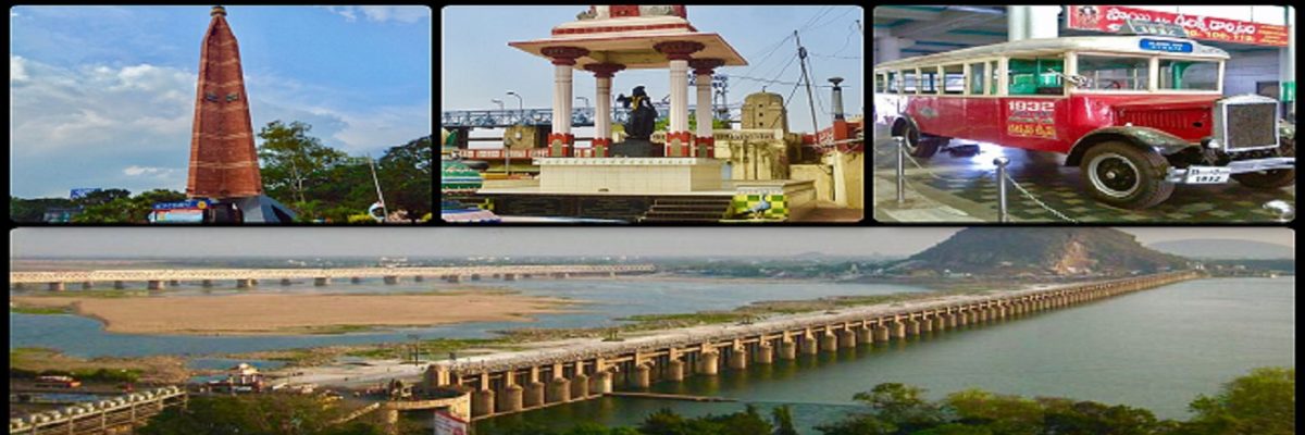
Prakasam Barrage:
The structure of the Prakasam Barrage stretches 1223.5 m across the Krishna River connecting Krishna and Guntur districts. The barrage serves also as a road bridge and spans over a lake. The three canals associated with the barrage run through the city of Vijayawada, crossing it and giving it a Venetian appearance.
The idea of constructing a dam across the river Krishna dates back to 1798. It began in the hands of captain Buckle and was revised in 1839 and 1841 by Captain Best and Captain Lake. After the endorsement of Major Cotton, the board of Directors of the East India Company approved it on 5 January 1850. The dam was started in 1852 and completed in 1855. It cost Rs 1.75 crore in those days and seems to have paid the then government a return of 18%. It used to irrigate 7 lakh acres. Later, the State Government constructed a bridge that was named after Tanguturi Prakasam, the first Chief Minister of Andhra (a state formed in 1953, which later became Andhra Pradesh in 1956 after the merger of Telugu speaking districts of former Hyderabad State). Completed in 1957, it helps to irrigate over 1.2 million acres of land. This barrage also supplies water to Buckingham canal which was initially constructed as an inland navigation canal but was later used as an irrigation water supply canal. One of the first major irrigation projects of South India, the Prakasam Barrage in Vijayawada was completely successful in its mission.
Andhra Pradesh largely owes its rich agriculture to the Prakasam Barrage as the project facilitated the irrigation of large tracts of farmland. The Barrage provides views of the lake. It has become a tourist attraction of Vijayawada. On 13th Feb-2019 Andhra Pradesh chief minister Nara Chandrababu Naidu laid foundation to construct a new barrage named Vykuntapuram Barrage on krishna river nearly 25 km upstream of Prakasam Barrage.
Krishna River:
The Krishna River is the fourth-biggest river in terms of water inflows and river basin area in India, after the Ganga, Godavari and Brahmaputra. The river is almost 1,400 kilometres (870 mi) long. The river is also called Krishnaveni. It is one of the major sources of irrigation for Maharashtra, Karnataka, Telangana and Andhra Pradesh. The Krishna river originates in the Western Ghats near Mahabaleshwar at an elevation of about 1,300 metres (4,300 ft), in the state of Maharashtra in central India. It is one of the longest rivers in India. The Krishna river is around 1,400 kilometres (870 mi) in length (282 kilometres (175 mi) in Maharashtra). The river’s source is at Mahabaleshwar near Jor village in the extreme north of Wai Taluka, Satara District, Maharashtra in the west and empties into the Bay of Bengal at Hamasaladeevi (near Koduru) in Andhra Pradesh, on the east coast. It flows through the state of Karnataka before entering Telangana State. The delta of this river is one of the most fertile regions in India and was the home to ancient Satavahana and Ikshvaku Sun Dynasty kings. Vijayawada is the largest city on the Krishna.
Bhavani Island:
Bhavani Island situated in the midst of the Krishna River, at Vijayawada. It is located at the upstream of Prakasam Barrage and is considered as one of the largest river islands in India, with an area of 133 acres (54 ha). The Kanaka Durga Temple is the abode of Goddess Durga. She is also known with another name as Bhavani and hence, the island is named Bhavani Island. The island is located in close proximity to the temple. Andhra Pradesh Tourism Development Corporation has taken initiatives to develop the place into a tourist spot. One such initiative is Shilparamam, an arts and crafts village project. It is also helpful for local artisans such as Kondapalli toy makers, weavers etc. APTDC has developed infrastructure on Bhavani Island to attract many tourists, which include sporting activities, resorts, rural museum, Berm Park, rope-way etc.
Undavalli Caves:
The Undavalli Caves, a monolithic example of Indian rock-cut architecture and one of the finest testimonials to ancient viswakarma sthapathis, are located in Undavalli of Guntur district in the Indian state of Andhra Pradesh. The caves are located 6 km south west from Vijayawada, 22 km north east of Guntur City of Andhra Pradesh. It is one of the centrally protected monuments of national importance. These caves are said to be found in 7th century. They are associated with the Vishnukundi kings of 420-620 CE. These caves are dedicated to Anantha Padmanabha and Lord Narashimha. Buddhist monks used these as rest houses.
These caves were carved out of solid sandstone on a hillside in the 4th to 5th centuries CE. There are several caves and the best known largest one has four stories with a huge recreated statue of Vishnu in a reclining posture, sculpted from a single block of granite inside the second floor. Many Buddhist artifacts and stupas in Andhra were converted into Hindu temples and deities and undavalli is an example. It was originally a Jain cave resembling the architecture of Udayagiri and Khandgiri. The main cave is one of the earliest examples of Gupta architecture, primarily primitive rock-cut monastery cells carved into the sandstone hills. Initially, the caves were shaped as a Jain abode and the first-floor abode still retains the Jain style; the vihara exhibits Jain monastics and includes tirthankara sculptures. This first level of the cave is a carved vihara and includes Buddhist artwork. The site served as the Bhikkhu monastic complex during ancient period. The walls of the caves display sculptures carved by skilled craftsmen.
The caves are surrounded by green countryside. From the high hill above the cave overlooking the Krishna River many fine specimens of rock-cut architecture can be seen.
The only means of connectivity for the caves is by road. APS RTC operates bus services from Vijayawada, Guntur and Amaravathi to this location. APCRDA runs Tourist Bus-cum-Boat services through Krishna River from Prakasam Barrage.
Rajiv Gandhi Park:
Created by the Vijayawada Municipal Corporation with great care, this park welcomes the tourists at the entrance of the city with its impressive horticultural network. It includes a mini zoo and a musical water fountain. This park is open from 2pm to 8pm.
Gandhi Hill:
The first Gandhi memorial with seven stupas in the country was constructed on this hill at a height of 500 ft (150 m). The 52 ft (16 m) stupa was unveiled on 6 October 1968 by Dr. Zakir Hussain, the President of India. Gandhi Memorial Library, a sound and light show on Mahatma Gandhi’s life and a planetarium are the other attractions.
Victoria Jubilee Museum:
A place for archaeology lovers, this museum has a carefully preserved collection of ancient sculptures, paintings, idols, weapons, cutlery, and inscriptions. This museum is closed temporarily due to repair works.
Mogalarajapuram Caves:
These caves are said to be excavated in the 5th century A.D. They are reputed to be the first of their kind in South India. The idols of Lord Nataraja, Vinayaka and Arthanareeswara are carved here, but none of the statues are available here.
Marakata Rajarajeswari Temple:
A unique temple of the goddess completely built with stone with intricate architecture symbolizing SRICHAKRA – the abode of mother Goddess.
Subramanya Swamy Temple:
One of the most popular temples in Vijayawada, it is located on a hill (Indrakeeladri) overlooking the city as well as the River Krishna. One can take to the steps on foot. During Skanda Shashti Festival, thousands of devotees come from the city. Many regular devotees will come from Tamil Nadu. This temple is maintained by the Iddipilli family.
Sri Nagarala Sri Maha Lakshmi Ammavaru Temple:
One of the most popular temples in Vijayawada, it is located in the area of Chiitinagar. During Dasara Festival, thousands of devotees from the city visit this temple. It is maintained by the Nagaralu community.
Gunadala Mary Matha Church:
In 1925, Rf. Arlati, the Rector of St. Joseph’s Orphanage at Gunadala, installed a statue of Our Lady and later a church was built and consecrated in 1971, now popularly known as St. Mary’s church. Since then the Feast of Our Lady of Lourdes became an annual event here, attended by hundreds of people. The church is situated on a hillock on the eastern side of the city.
Mangalagiri:
Mangalagiri is a town in Guntur district situated between the twin cities of Vijayawada and Guntur of the Indian state of Andhra Pradesh. The town is the headquarters of Mangalagiri mandal under Guntur revenue division. It is a major suburb of the cities of Vijayawada and Guntur. It also forms a part of the Andhra Pradesh Capital Region. It is situated on National Highway 16 between Vijayawada and Guntur. The town was known to have existed since 225 B.C.
Mangalagiri is located at 16.43°N 80.55°E. It has an average elevation of 29.08 m (95.4 ft).It is located 26 kilometres (16.2 mi) north east of the district headquarters, Guntur, and just 10 kilometres (23 mi) south west of Vijayawada and also 30 kilometers ((18.7 mi)) to the south of Tenali by road. It lies on hilly terrain. It falls under Seismic Zone 3.
Mangalagiri Tourism:
Lakshmi Naramisha Temple is the abode of Lord Vishnu, who manifested himself as Thotadri, is present in Mangalagiri. There are three Narasimha Swamy temples. Undavalli caves, located near Mangalagiri, a specimen of Indian rock-cut architecture. The historic caves are located at the top of the hills overlooking the Krishna River, built during the 4th-5th century. Dedicated to Ananta Padmanabha Swamy and Narasimha Swamy, Undavalli Cave Temples are associated with the Vishnukundina kings. Hinkar Thirtha Jain Temple, located in Namburu is the largest Jain temple in the region, visited by many Jains, from different parts of the state.
Panakala Lakshmi Narasimha Temple, Mangalagiri:
Lakshmi Narasimha Temple is a vaishnavite temple and one of the eight sacred places of Lord Vishnu in India. It is situated at the foot of the Auspicious Hill in Mangalagiri of Guntur district of Andhra Pradesh. It is one of the temple in the series of three temples located on and at the bottom of the hill, the other two being Panakala Narasimha Temple on the hill and Gandala Narasimha Temple at the top of the hill. It has one of the highest gopurams in South India and only one of its type in this part of India. It is 153 feet (47 m) in height and 49 feet (15 m) wide and has eleven storeys.
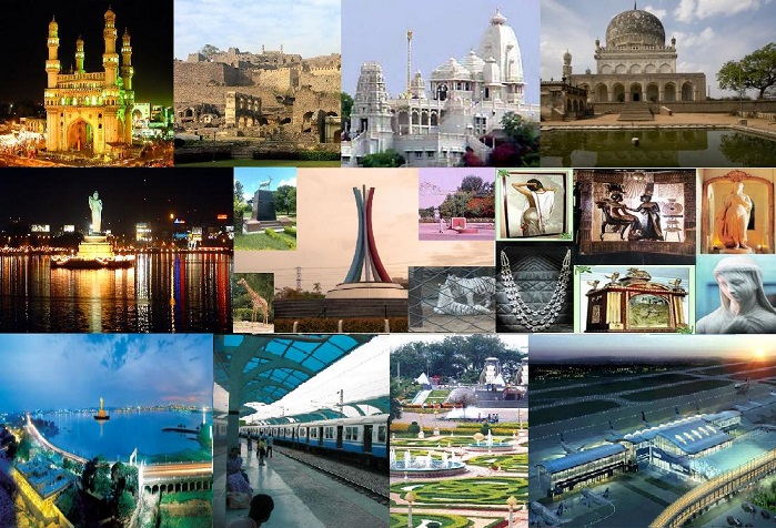
Vizag (Visakhapatnam) Tourism Online | Tourism of Vizag
Vizag(Visakhapatnam) Tourism: Tourism of Vizag(Visakhapatnam) | AP Tourism
Visakhapatnam Tourism:
Visakhapatnam is a also Well known as Vizag and Valteru Names. it is a port city and industrial center in the Indian state of Andhra Pradesh, on the Bay of Bengal. It’s known for its many beaches, including Ramakrishna Beach, home to a preserved submarine at the Kursura Submarine Museum. Nearby are the elaborate Kali Temple and the Visakha Museum, an old Dutch bungalow housing local maritime and historical exhibits.
RK Beach:
RK Beach also known as Ramakrishna Beach is situated on the East coast of Bay of Bengal in Visakhapatnam. It is located near Dolphin’s Nose. Dolphin’s Nose is a hill in Visakhapatnam between Yarada and Gangavaram Port. The hill is named Dolphin’s Nose because it resembles a dolphin’s nose.
Before independence the British Army used it as a Military Camp. There is a Hindu Temple, a Church, and a Mosque on a nearby hill. In 1804 British and French forces fought near this hill. and the battle is called the Battle of Vizagapatam. A lighthouse on this hill guided ships to enter Visakhapatnam Port. Recently Government of India is planning to start lighthouse tourism.
One of the most popular beaches of Vizag is Ramakrishna beach, more commonly known as RK beach. RK Beach gets its name from the Ramakrishna Mission ashram situated near the beach. It is one of the very pleasant and most crowded beach in the country With its serene waters and cool atmosphere, the beach offers a wonderful view of the countryside.
Varaha Lakshmi Narasimha temple, Simhachalam:
The Sri Varaha Lakshmi Narasimha temple, Simhachalam is a Hindu temple situated on the Simhachalam hill, which is 300 metres above the sea level in Visakhapatnam, Andhra Pradesh. It is dedicated to one of the Hindu trinity deities Vishnu, who is worshipped there as Varaha Narasimha. As per the temple’s legend (which is divided into 32 chapters), Vishnu manifested in this peculiar form, with a boar head, human torso and a lion’s tail, after saving his devotee Prahlada from a murder attempt by the latter’s father Hiranyakashipu. Except on Akshaya Tritiya, the idol of Varaha Narasimha is covered with sandalwood paste throughout the year, which makes it resemble a linga.
Simhachalam is one of the 32 Narasimha temples in Andhra Pradesh which are important pilgrimage centres. It was regarded as an important centre of Vaishnavism in the medieval period along with Srikurmam and others. The temple has been recognised by historians with the help of a 9th-century AD inscription by the Chalukya Chola king Kulottunga I. In the later half of the 13th century, the temple complex underwent radical physical changes during the reign of the Eastern Ganga king Narasimhadeva I. It later received patronage from many royal families, of which Tuluva dynasty of Vijayanagara Empire is a notable one. The temple underwent 40 years of religious inactivity from 1564 AD to 1604 AD. In 1949, the temple came under the purview of the state government and is currently administered by the Simhachalam Devasthanam Board.
Simhachalam temple resembles a fortress from outside with three outer courtyards and five gateways. The architecture is a mixture of the styles of the Kalinga Architecture/Odishan(Orissan), Chalukyas and the Cholas. The temple faces west instead of east, signifying victory. There are two temple tanks: Swami Pushkarini near the temple and Gangadhara at the bottom of the hill.
Simhachalam is the second-largest temple, after Tirumala in Andhra Pradesh, in terms of income earned. Devotees believe that the deity is capable of giving progeny to women and fulfilling the wishes of devotees. Kalyanotsava and Chandanotsava are the two major festivals celebrated in the temple, followed by Narasimha Jayanti, Navaratrotsava and Kamadahana. The festivals celebrated in Simhachalam have an influence of the Dravida Sampradaya. Apart from those by well-known poets, the temple is found in many literary references and lyrical works (dedicated by anonymous writers), which are preserved in the Government Oriental Manuscripts Library, Chennai.
Kailasagiri:
Kailasagiri is a hilltop park in the city of Visakhapatnam in the Indian state of Andhra Pradesh. The park was developed by the Visakhapatnam Metropolitan Region Development Authority (VMRDA) and comprises 380 acres (150 ha) of land covered with flora and tropical trees. The hill, at 173 metres (568 ft), overlooks the city of Visakhapatnam.
The Government of Andhra Pradesh awarded Kailasagiri as its “Best Tourist Spot” in 2003. On average, around three hundred thousand Indian and foreign tourists visit the park every year. To protect the environment, VMRDA has declared the hill a plastic-free zone.A cable car connects to the top of the hill, the first of its kind in Andhra Pradesh.
Visakhapatnam Port:
Visakhapatnam Port is one of 12 major ports in India and the only major port of Andhra Pradesh.It is the deepest landlocked well protected port . It is India’s second largest port by volume of cargo handled. It is located on the east coast of India and is located midway between the Chennai and Kolkata Ports.
Although the need for building a port on the east coast to access Central Provinces was felt by the British in the 19th century, the proposal of Col. H.Cartwright Reid of British Admiralty for constructing a harbour at Visakhapatnam was approved by the Government only after the First World War. The Inner Harbour was built by the Bengal Nagpur Railway between 1927 and 1933 to facilitate the export of manganese ore from the Central Provinces. The port, built at a cost of ?378 lakhs was inaugurated by Lord Willingdon on 19 December 1933.
During the Second World War, the military significance of the port increased. After India’s independence, the port witnessed growth under the various Five Year Plans. Over time, the port has grown from one with 3 berths handling 1.3 lakh tonnes per annum to one with 24 berths and annual traffic of 65 million tonnes. The port was notified as a major port in 1964 under the Major Port Trusts Act, 1963. Under the Act, the Visakhapatnam Port Trust is in charge of running the port.
Visakhapatnam Port has three harbours – the outer harbour, inner harbour and the fishing harbour. The outer harbour has 6 berths capable of handling vessels with a draft up to 17 meters while the smaller inner harbour has 18 berths that are Panamax compatible. Vizag Seaport owns two berths in the inner harbour; berth EQ-8 is fully mechanised and berth EQ-9 berth is not.
The Dolphin’s Nose Hill to the north of the entrance channel protects the harbour from cyclones that strike the east coast. The port is located on the area of a creek through which the coastal river Narava Gedda joins the sea.
Satellite port at Bhimili:
The Visakhapatnam Port Trust plans to develop a satellite port at Bheemunipatnam to decongest traffic at Visakhapatnam. The project is expected to cost ?2,000 crores and is to be undertaken through a Public- Private Partnership (PPP) venture.
Tenneti Park:
Tenneti Park also known as (Vuda Tenneti Park) is an Urban park in the city of Visakhapatnam, India. Situated on the Beach Road in Jodugullapalem, it the first children’s park, and one of the oldest parks in the city. It is located beside Sea Shore of Bay of Bengal. GVMC installed LED screens in the park to boost Tourism in the city
Beach Road, Visakhapatnam:
Beach Road (also known as, Visakhapatnam Beach Road) is a major highway road in Visakhapatnam. It is home for Tourist destinations such as RK Beach and Kailasagiri. The Beach Road has cultural importance with the presence of buildings and structures such as, Rajiv Smruthi Bhavan (city’s cultural hub), Annamayya Mandapam, AU Convention Center and organising rallies, city parades etc.
Rushikonda Beach:
Rushikonda Beach located in Visakhapatnam on the coast of Bay of Bengal in the Indian state of Andhra Pradesh. The beach is maintained by the state tourism board, APTDC.
Dolphin’s Nose:
Dolphin’s Nose is a hill in Visakhapatnam between Yarada and Gangavaram Port. The hill is named Dolphin’s Nose because it resembles a dolphin’s nose.
Before independence the British Army used it as a Military Camp. There is a Hindu Temple, a Church, and a Mosque on a nearby hill. In 1804 British and French forces fought near this hill. and the battle is called the Battle of Vizagapatnam.
Lighthouse:
A lighthouse on this hill guided ships to enter Visakhapatnam Port.Recently Government of India is planning to start lighthouse tourism.
Yarada:
Yarada is a neighborhood situated on the Visakhapatnam City, India. It is famous for its beach and a hill road to reach the beach. It is one of the scarcely populated beaches in the city. The area, which falls under the local administrative limits of Greater Visakhapatnam Municipal Corporation and is well known for Yarada Beach. Yarada is a part in Gajuwaka Mandal.
Yarada Beach:
Yarada Beach is situated on the west coast of Bay of Bengal in Yarada, a village at a distance of 15 kilometres (9.3 mi) from Visakhapatnam. It is located near Gangavaram beach, Dolphin’s Nose, and Gangavaram Port. This is a very picturesque beach in Andhra pradesh. A scientific study of the characteristics of the sediments deposited at the beach was conducted from May 2009 to May 2010. The study found that the location of Pigeon Hill has a major impact on how deposits are added to the beach and removed through erosion.
Indira Gandhi Zoological Park:
Indira Gandhi Zoological Park is located amidst Kambalakonda Reserve Forest in Visakhapatnam, Andhra Pradesh, India. It is the third largest zoo in the country.
The zoological park is named after the former Prime Minister of India, Indira Gandhi. It was declared open to the public on 19 May 1977. It covers an area of 625 acres (253 ha). It is situated in Visakhapatnam amidst the scenic Eastern Ghats of India. It is surrounded by the Eastern Ghats on three sides and Bay of Bengal on the fourth side. Nearly eighty species of animals numbering to about eight hundred are present in the zoo. The Zoo Park has different sections for primates, carnivores, lesser carnivores, small mammals, reptiles, ungulates and birds caged in their natural ambiance.
The zoo park is about 11 kilometres (6.8 mi) from the Visakhapatnam railway station on the National Highway 5 near Madhurawada. It has entrance and exit gates situated oppositely, with one towards National Highway 5 and the other towards Beach Road at Sagar Nagar. It is open to public daily except Monday.
625 acres (253 ha) land area with abundant flora & fauna. Nearly 80 species of mammals, birds, and reptiles are present in the zoo (more than 800 animals).
In collaboration with Stardust Ventures LLP, Vizag zoo launched a web portal, to engage the community with latest events. It also allows general public to adopt an animal for certain time period.
In an area of 625 acres (253 ha) the zoological park located among the Kambalakonda Wildlife Sanctuary of Eastern Ghats, the zoo has enclosures for primates, carnivores, lesser carnivores, small mammals, reptiles, ungulates and birds aviaries with a well-planned layout map, a jungle along a water body inside the zoo park. The animal exhibits in the zoo park are as follows:
Birds:
Endemic: Pelican (rosy and gray), Painted stork, Peafowl, Duck, Spotted dove, Lovebird, Parakeet, Eagle, Vulture.
Exotic: Budgerigar, Macaw, Ostrich, Emu.
Primates:
Endemic: Bonnet monkey (common Indian monkey), chimpanzee, Rhesus monkey.
Exotic: Olive baboon, Mandrill, Ring-tailed lemur (lemur catta), Goeldi’s marmoset. Most Recent inclusion is the new primate species i.e.., three Chimpanzees which were brought from Tisch Zoo in Jerusalem under an agreement done by the Government of India with Israel’s Nature Parks Authority.
Herbivores:
Endemic: Barking deer, Elephant, Wild boar, Gaur, Sambar deer, Spotted deer, Nilgai, Swamp deer, Eld’s deer (thamin deer), Indian rhinoceros.
Exotic: Hippopotamus and Giraffe.
Carnivores:
Endemic: Tiger (Leucistic and Bengal), Leopard and Cheetah.
Exotic: Puma and Jaguar.
Lesser carnivores:
Endemic: Jackal, Wild dog, Striped hyena, Rusty-spotted cat, Dhole, and Jungle cat.
Bears:
Endemic: Sloth bear, Himalayan black bear.
Reptiles:
Endemic: Python, Cobra, King cobra, Rat snake, Indian star tortoise, Tortoise, Terrapin, Water monitor lizard, Monitor lizard, Green iguana, Mugger crocodile and Gharial.
Along with this, Butterfly park and Nocturnal Animal House which has Owls, Porcupines, and Civets are special attraction.
Kambalakonda Wildlife Sanctuary:
The Kambalakonda Wildlife Sanctuary is a forest located near Visakhapatnam. It has been under the control of Andhra Pradesh Forest Department since 10 March 1970. Earlier the land was under the control of Maharajah of Vizianagaram. It was named after the local hillock Kambalakonda. It is a dry evergreen forest mixed with scrub and meadows and covers an area of 70.70 square kilometers. The indicator species is the Indian leopard.
The sanctuary is located from latitudes of 17.34° N to 17.47° N and longitudes of 83.04° E to 83.20° E. The location corresponds to an area west of National Highway 16 on the northern side of Visakhapatnam and Pendurthi in Visakhapatnam district. It can be reached by road about 3 km from Visakhapatnam, opposite to zoo park. The sanctuary has a dry evergreen forest mixed with scrub and meadows. The terrain is hilly with steep slopes.
There is diverse flora and fauna in this sanctuary representing the Eastern Ghats.
Kondakarla Ava:
Kondakarla Ava is a famous Lake and Bird Sanctuary in Visakhapatnam of Andhra Pradesh state in South India. It comprises a unique and endangered forest type. It is located in the foothills of Eastern Ghats.
Kondakarla Ava is located in Visakhapatnam District of Andhra Pradesh, in Kondakarla village, Atchutapuram Mandal. It is managed by the Andhra Pradesh Tourism Development Corporation and Kondakarla Panchayat. The Sanctuary comprises a unique and endangered forest type and the wet evergreen forests. It is recognized as an Eco Tourism destination.
Wet evergreen forest type with species like Shelducks, Common Teals, Northern Pin Tails and Asian Open Bills are found in the sanctuary and Typha angustata, Nymphoides indica, Azolla filiculoides, Pistia stratiotes are also found here.
Mudasarlova Park:
Mudasarlova Park is an urban park in the Indian city of Visakhapatnam. It is spread over 20 acres (8.1 ha) of land. it was constructed in 1902 and is one of the oldest parks in this Coastal Andhra. The water reservoir in the park supplies drinking water to the city. It was named one of the best picnic spots for local citizens. The land for the construction of Mudasarlova was donated by Sri Pusapati Ananda Gajapati Raju (Ex-MP, Visakhapatnam) from his family trust.
Mudasarlova Park has the oldest Water reservoir in Visakhapatnam. It supplies 1 million gallons water per day. this reservoir constructed by the British in 1901.
The Floating solar power plant was built in 20 acres of the reservoir, among the oldest man-made water bodies, on the outskirts of the city, at a cost of 11.34 crore.
Bheemili Beach:
Bheemili Beach is located at the origin of the Gosthani River, at a distance of 24 km from Visakhapatnam in Visakhapatnam district of the Indian state of Andhra Pradesh. The beach reflects the British and Dutch settlements of the 17th century.
Appikonda:
Appikonda is a neighborhood situated on the southern part of Visakhapatnam City, India,and is about 30 km from the Visakhapatnam. Appikonda is famous for Someswara Swamy Temple.
Someswara Swamy Temple, Appikonda:
Sri Someswara Swamy Temple is a temple to Shiva located in Appikonda, Visakhapatnam. This temple was built in 1070 by King Kulottunga I of the Chola dynasty, and referred to as the Chola Monument. Someswara Temple is very popular. In this region, for Maha Shivratri more than 1 lakh (100,000) devotes will visit during the festival. The temple was declared a protected monument by the Archaeological Survey of India.